Researchers have integrated mobile lidar technology and open-source tools to automate urban tree inventories. This approach enhances efficiency and affordability in mapping and measuring urban trees, which is crucial for environmental planning and ecosystem service assessment, offering significant benefits for city planning and management.
The Importance of Urban Trees
Urban trees are vital components of city landscapes, offering numerous environmental benefits such as improved air and water quality, carbon sequestration, temperature regulation, and biodiversity enhancement. However, to harness these benefits fully, it is essential to accurately map, identify, and measure individual trees. Traditional methods of urban tree inventories are resource-intensive and time-consuming, often requiring detailed field measurements of each tree. This process can be a significant bottleneck in urban planning and environmental management, where timely and accurate data is crucial for decision-making.
The need for efficient and cost-effective methods to conduct urban tree inventories has led researchers to explore automation through remote sensing technologies. Lidar, a remote sensing method that uses light in the form of a pulsed laser to measure variable distances, has emerged as a promising tool in this field. By integrating lidar with aerial photography, researchers aim to improve the efficiency and affordability of urban tree inventories. This approach not only aids in the assessment of tree biometrics but also plays a critical role in city planning, identifying hazardous trees, and evaluating trees’ impact on carbon and water cycles.
Innovative Methodologies in Tree Inventory
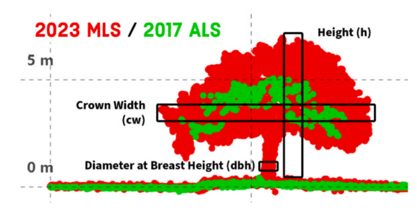
The research conducted by Justinn J. Jones and colleagues at Texas A&M University focused on developing a fully automated approach to urban tree inventories using mobile lidar and open-source tools. The study aimed to map and model urban trees and estimate their biophysical parameters, including tree height, diameter at breast height (dbh), and crown width. To achieve this, the researchers utilized a combination of aerial and mobile lidar data, complemented by high-resolution aerial photography.
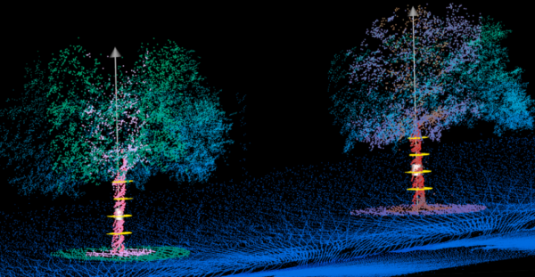
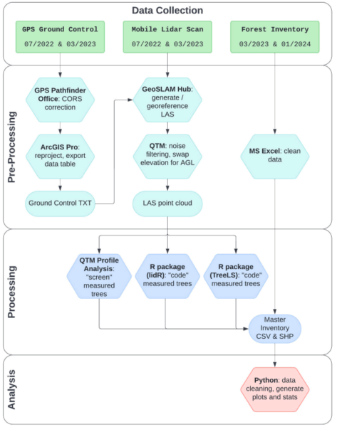
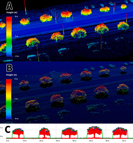
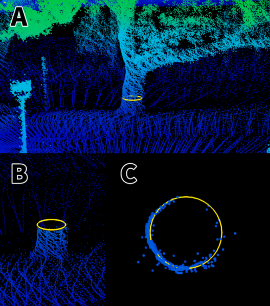
The methodology involved several key steps. First, the researchers developed protocols for mobile lidar data collection, using a handheld scanner that could be mounted on a backpack, vehicle, or drone. This approach, known as terrestrial mobile lidar scanning (MLS), provides a detailed reconstruction of tree stems and canopies from a ground-based perspective. The study also explored the use of airborne lidar scanning (ALS) for large-scale data collection, offering a bird’s eye view of the tree canopy.
Two open-source R packages, lidR and TreeLS, were employed to automate the digital tree measuring process. These tools facilitated the remote measurement of trees from lidar point clouds, serving as an efficient surrogate for traditional field inventories. The lidR package was used to generate tree height estimates, while TreeLS focused on measuring dbh. The integration of these tools into the workflow enabled the automation of tree measuring and validation processes, significantly enhancing the efficiency of urban tree inventories.
Key Findings and Insights
The study demonstrated the effectiveness of mobile lidar data collection as a viable alternative to traditional forest inventory methods. The lidR package successfully generated tree height estimates, with an R² of 0.74 for large trees and 0.82 for shorter trees, indicating strong correlations between the predicted and actual heights. The TreeLS package provided accurate dbh measurements, achieving an R² of 0.91. These results underscore the potential of mobile lidar and open-source tools to revolutionize urban tree inventories by providing accurate and efficient measurements.
The research highlights the advantages of using mobile lidar for urban tree inventories, including lower costs and higher temporal resolution compared to traditional methods. The ability to automate the measurement process not only reduces the time and resources required but also enhances the accuracy and reliability of the data collected.
Future Implications and Applications
This research paves the way for more efficient and cost-effective urban tree inventories, with significant implications for city planning and environmental management. By automating the measurement process, municipalities and urban planners can systematically monitor urban forests, assess risks, and develop climate adaptation strategies. The integration of mobile lidar with open-source tools offers a scalable solution that can be adapted to various urban environments, potentially transforming how cities manage their green infrastructure.
We thank the authors for their valuable contribution to this field. For those interested in further exploring this innovative approach or contributing insights, the research offers a promising foundation for future advancements in urban forestry management.
Reference: Justinn J. Jones, Sorin C. Popescu, Joshuah S. Perkin, Stephen L. Webb. “Toward fully automated urban tree inventory: Integrating mobile lidar and open-source tools.” Urban Forestry & Urban Greening, 118 (2026) 129362. DOI: https://doi.org/10.1016/j.ufug.2026.129362