The Rise of Regenerative Wind Farms
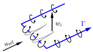
Regenerative wind farms with MRSLs nearly double efficiency, transforming renewable energy landscapes and reducing costs.
The Rise of Regenerative Wind Farms Read More »
Regenerative wind farms with MRSLs nearly double efficiency, transforming renewable energy landscapes and reducing costs.
The Rise of Regenerative Wind Farms Read More »
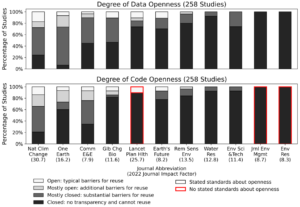
Researchers highlight the critical role of transparency and reusability in climate risk management, revealing that only a small fraction of studies fully share their data and code.
Open science for Climate Risk Read More »
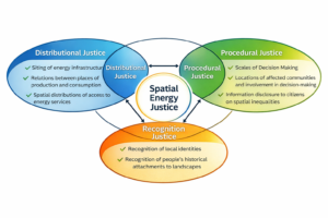
This study examines the spatial dynamics of energy justice by engaging citizens in discussions about regional energy transitions.
Energy Justice in Regional Transitions Read More »
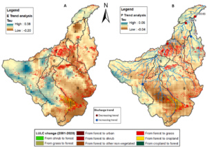
Explore the spatial and temporal shifts in precipitation, evaporation, and streamflow linked to deforestation in the Madeira River basin, the Amazon’s largest sub-basin, through analysis of satellite, reanalysis, and observed data from 1981 to 2016, highlighting significant correlations that inform regional water resource strategies. Deforestation Challenges in the Madeira River Basin The Madeira River basin
Uncovering Links Between Forest Loss and Water Dynamics in the Amazon Read More »
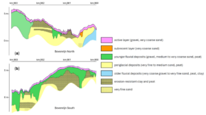
Exploring River Dynamics: A Review of Three Decades of Studies on Human-Induced Changes in the Lower Rhine, Emphasizing 2D Modeling for Transverse Sediment Variations, Bifurcation Stability, and Non-Erodible Layer Effects in Large-Scale Bed Profile Management Human Interventions in the Lower Rhine: Challenges and Significance The lower Rhine, including the Niederrhein in Germany and the delta
Morphological Evolution of the Lower Rhine Read More »
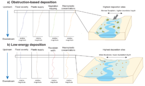
This study analyzes macroplastic deposition on river floodplains across 14 events, including five floods, along Dutch rivers, demonstrating higher deposition during severe floods and varying mechanisms based on flood type, offering valuable data for addressing riverine plastic pollution in environmental management. Understanding Macroplastic Pollution in Rivers Macroplastic pollution, plastic items larger than 5 mm, poses
Flood Characteristics and Macroplastic Deposition in Rivers Read More »
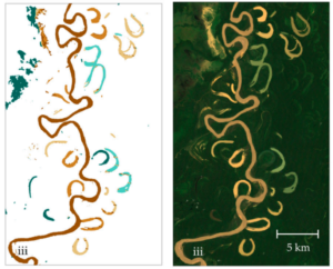
This study employs Google Earth Engine and Landsat 7 imagery alongside random forest classification to analyze multitemporal trends in oxbow lake area, water types, and hydrologic connectivity, providing insights into ecohydrological processes and fish habitat availability in data-scarce tropical river systems such as Bolivia’s Beni River. Challenges in Floodplain Dynamics Monitoring Meandering river floodplains, such
Remote Sensing for Oxbow Lake Monitoring in Turbid Floodplains Read More »

GlobalBuildingAtlas introduces an open dataset with global coverage of 2.75 billion building polygons, 3 m resolution height maps, and LoD1 3D models, derived from satellite imagery, offering enhanced detail for urban analysis, planning, and monitoring progress toward the UN’s Sustainable Development Goals. The Need for Detailed Global Building Information Buildings serve as the foundation of
The Comprehensive Global Building Dataset: GlobalBuildingAtlas Read More »

A structured Delft–Amsterdam research collaboration integrates bridge typologies, expected failure mechanisms, and satellite viewing geometry to translate one-dimensional MT-InSAR measurements into practical damage indicators, demonstrating how regional-scale millimetre-level displacement data can support systematic structural evaluation of urban bridge networks. The Urban Bridge Monitoring Dilemma Across Europe and beyond, bridge networks are aging under increasing traffic
Monitoring Amsterdams Bridges with InSAR Read More »
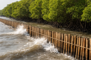
In Demak, Indonesia, a pilot deployment of bamboo and PVC permeable structures paired with systematic low-cost monitoring uncovers detailed seabed dynamics on a subsiding coast, highlighting both challenges and opportunities for nature-based mangrove restoration in complex coastal environments. Coastal Erosion and Subsidence: The Urgent Need for Effective Mangrove Restoration Mangroves provide essential coastal protection against
Bamboo Solutions for Mangrove Restoration Read More »