Researchers have developed an interpretative model to manage seismic risk in historic city centers, focusing on Fiumefreddo Bruzio in Southern Italy. This multidisciplinary approach integrates geomatics, structural engineering, and urban planning to provide a comprehensive framework for protecting cultural heritage from seismic threats.
Seismic Vulnerability in Italy’s Historic Centers
Italy’s historic city centers, known for their cultural and architectural significance, face a major challenge: seismic vulnerability. These areas, often featuring unreinforced masonry and aging infrastructure, are particularly prone to earthquakes. This vulnerability threatens cultural heritage preservation and impacts the economy and tourism. Addressing this issue is crucial for regional risk reduction strategies. Developing methodologies that are both precise and scalable for managing seismic risk at an urban scale is essential. Traditional analytical approaches often fall short in extensive urban environments, highlighting the need for integrated, multidisciplinary methods.
The Italian GENESIS project aims to enhance and preserve Southern Italy’s historic centers by developing multi-scale seismic risk assessment methodologies integrated within a digital information system platform. This study presents an interpretative model for managing seismic risk in historic city centers, emphasizing interdisciplinarity by merging structural engineering, geomatics, conservation strategies, and urban planning.
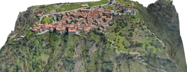
The study focuses on Fiumefreddo Bruzio, a historic center in Calabria, Southern Italy, characterized by medium-low quality masonry buildings. The population swells during the summer, complicating emergency management. The city center’s location on a small hill with limited access further challenges emergency planning and evacuation efforts.
Advanced Techniques in Seismic Risk Assessment
The study’s methodology involves a multi-sensor, multi-scale geometric survey to meet the needs of seismic risk engineers and cultural heritage managers. This includes analyzing cartographic resources and establishing a geodetic control network using GNSS benchmarks. Field operations integrate terrestrial and UAV photogrammetry, static laser scanning, and mobile SLAM mapping to ensure comprehensive 3D documentation.
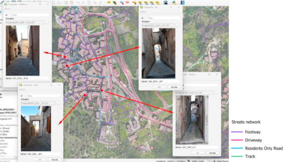
A DJI Mavic 3 quadcopter captures 8,850 nadiral and oblique RGB images at about 2 cm ground sampling distance, while SLAM mapping supplements data collection in UAV-inaccessible areas. Additionally, 3,500 terrestrial photos taken with a Nikon Z7 camera cover the narrowest streets and façades, achieving sub-centimetre detail. Key buildings such as Castello di Valle, Santa Maria de Andexis, and others are surveyed at a 1:50 scale with less than 1 cm uncertainty.
Data processing involves orienting photogrammetric blocks using structure-from-motion techniques and integrating point clouds from all sources into a unified reference frame. The resulting multi-resolution dataset supports the creation of full-color urban orthophotos, digital terrain models (DTM), digital surface models (DSM), contour maps, and continuous textured mesh at an urban scale. Additionally, façade orthophotos, architectural drawings at 1:50 scale, and high-resolution orthophotos of castle frescoes are produced.
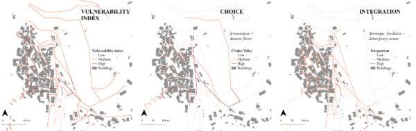
This integrated approach provides a metrically accurate, information-rich 3D model supporting both seismic vulnerability analysis and informative applications for tourism. Street and path mapping identifies vulnerabilities and promotes touristic valorization by suggesting optimal routes for tourists and identifying potential obstacles in escape routes. The outcome is an interrogable GIS database for analyzing the vulnerability of the built environment and road infrastructure.
The study includes a seismic vulnerability assessment of masonry buildings using a quantitative-qualitative model. This model estimates a building’s collapse capacity in terms of Peak Ground Acceleration (PGA) and evaluates masonry piers’ shear strength, corrected by qualitative parameters accounting for construction quality and structural configuration. Integrated into the GENESIS platform, this methodology allows data retrieval through geo-referenced polygons for each building, providing stakeholders with detailed insights into the seismic resilience of individual structures.
The study demonstrates the potential of this model to manage seismic risk in historic city centers effectively. By combining advanced geomatics techniques with structural vulnerability assessment models, the model provides a comprehensive framework for seismic risk management and evacuation planning. This approach empowers stakeholders to make informed decisions regarding cultural heritage preservation and safety.
Reference: Balletti, C., Berto, L., Breggion, E., Faccio, P., Guerra, F., Martinelli, G. D., Rocca, I., Saetta, A., Talledo, D., “An interpretative model for seismic risk: the case of Fiumefreddo Bruzio in Southern Italy,” Procedia Structural Integrity, 2026. DOI: https://doi.org/10.1016/j.prostr.2025.12.232