In Demak, Indonesia, a pilot deployment of bamboo and PVC permeable structures paired with systematic low-cost monitoring uncovers detailed seabed dynamics on a subsiding coast, highlighting both challenges and opportunities for nature-based mangrove restoration in complex coastal environments.
Coastal Erosion and Subsidence: The Urgent Need for Effective Mangrove Restoration
Mangroves provide essential coastal protection against flooding and sea-level rise while supporting local economies through fisheries and other resources. However, these ecosystems have declined globally due to deforestation, conversion to agriculture and aquaculture, and diminished sediment supply from river damming, sand mining, and subsidence linked to groundwater extraction.
In Demak, on the north coast of Java, Indonesia, subsidence rates at the project site range from 0.05 to 0.1 m per year. The coastline consists mainly of soft mud, with migrating cheniers—sandy ridges that can shelter the shore and aid mangrove establishment when stable for more than a year. The mangrove fringe has retreated since at least 2018, with fallen trees visible at the vegetation edge.
Temporary permeable structures, typically constructed from bamboo and brushwood, have been implemented in various countries including Guyana, Suriname, Thailand, and Vietnam. These structures are intended to reduce wave energy while permitting tidal sediment transport, thereby promoting accretion to elevations suitable for mangrove colonization, generally near or above mean sea level.
Performance in prior projects has varied. In sheltered, accreting locations, some success has been observed; in higher-energy settings, structures have experienced erosion, undermining, or damage from storms and biological agents such as shipworms. Many earlier studies reported short-term accretion rates but often lacked comprehensive bathymetric data, spatial variability details, or control-site comparisons, limiting the ability to interpret results within the broader morphodynamic context.
In Demak, earlier pilots from 2014 to 2020 achieved 0.2–0.5 m of accretion during the first stormy season in some cases. However, none resulted in sustained mangrove recovery, as accretion did not reach the required elevations for pioneer species such as Avicennia marina or fully offset subsidence, and structures required ongoing maintenance. The mangrove edge continued to retreat.
Low-Tech Monitoring Methods Applied in the Demak Pilot
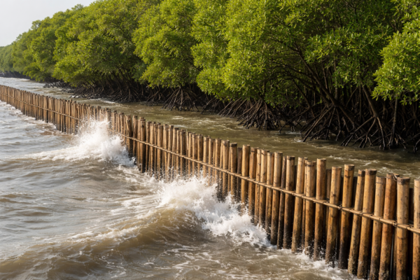
In late 2021, temporary permeable structures using bamboo and PVC poles were installed 500 m north of Timbulsloko village. The structures were positioned at water depths of −0.7 m to −0.9 m relative to mean sea level, 30–70 m seaward of the mangrove fringe and landward of a submerged chenier.
The design comprised 2–3 rows of poles with 5 m shore-normal spacing. Configurations included rows of vertical bamboo poles and sections with horizontal bamboo beams attached to concrete-filled PVC poles. Shore-parallel segments were typically 35 m long with 5 m gaps; an angled 43 m section supported navigation, and a 100 m row was added to the south. Brushwood fillings were not used, following previous experiences in the region where bags frequently broke or floated away.
The study applied a low-cost monitoring approach to generate data suitable for system understanding and morphodynamic modeling. Ten transects were monitored: five across the structures, four near drainage creeks, and one control site without structures.
Monitoring poles—PVC pipes filled with concrete and embedded approximately 1 m into the mud—were installed 10 m seaward, 10 m just landward, and 20 m further landward of the structures (with equivalent placement at the control). These poles initially extended 1.2 m above the seabed, allowing repeated measurements of the distance to the sediment surface to track relative bed-level changes from erosion, accretion, and consolidation.
Monthly bathymetric surveys measured water depth to the seabed every 10 m along each transect using a pole with a flat base plate to prevent sinking into soft sediment. Depths were referenced to mean sea level using tidal data from the Semarang station, with reliable corrections available until July 2022. Measurements were projected onto consistent shore-normal lines to account for minor path variations.
Observed Seabed Changes and Structure Performance
Bathymetric surveys from August 2021 to July 2022 showed a submerged chenier as shallower areas and drainage creeks extending from the mangrove stands. Over this period, several creeks deepened, while the chenier migrated landward and increased in crest height, locally rising above mean sea level.
At the control transect, the chenier started at −0.1 m relative to mean sea level and reached a maximum crest elevation of 0.23 m, with accretion behind it of up to approximately 0.1 m. The most landward points remained around −0.3 m relative to mean sea level. Monitoring poles recorded average accretion of 0.01 m at the most seaward pole, 0.08 m landward, and 0.13 m further landward.
In the structure transects, monitoring poles indicated average erosion seaward of the structures of −0.38 m (with values ranging from −0.33 m to −0.4 m). Just landward, the average change was −0.03 m, and further landward −0.05 m, with notable spatial variability (standard deviation up to 0.2 m).
Landward responses varied: two sections showed erosion of −0.04 m to −0.05 m, one section remained stable, and the creek-adjacent section experienced −0.43 m erosion at the further landward pole. Some localized accretion up to 0.1 m occurred during stormy periods in January–February 2022, though much of this sediment was subsequently lost. Most seaward erosion took place in the first two months.
Landward rows of structures T3 and T4 (using horizontal bamboo beams) collapsed or tilted by mid-January 2022 due to wave loading during the northwest monsoon; repairs were carried out in March–April 2022. Vertical bamboo pole rows remained more stable.
Satellite imagery indicated continued retreat of the coastline and mangrove fringe between 2021 and 2023 in both structured and control areas.
The study reports that bed elevations remained below the threshold needed for mangrove seedling establishment, both landward of the structures and at the control location. The authors note that the collected bathymetric and monitoring pole data constitute a valuable dataset for modeling studies on integrated mangrove restoration approaches in subsiding coastlines.
Implications for Mangrove Restoration in Subsiding Environments
The datasets from this pilot provide a basis for developing and validating morphodynamic models to better understand interactions between structures, cheniers, creeks, waves, and subsidence. Such models can support the evaluation of combined interventions, including sediment management and structure optimization.
The findings illustrate the importance of site-specific conditions and the potential value of durable or hybrid solutions in highly dynamic, subsiding settings.
The authors and research team are thanked for this well-documented contribution to the field of nature-based coastal engineering.
Engineers and researchers working on mangrove restoration or similar coastal projects are invited to share relevant field data, modeling insights, or practical experiences. Contact is welcome to support ongoing dialogue.
Reference:
Gijón Mancheño, A., Maulana, B., Reniers, A. J. H. M., Tas, S. A. J., Wilms, T., Rejeki, S., Ariyati, R. W., & Widowati, L. L. (2025). Monitoring Pilot Study of Temporary Permeable Structures for Mangrove Restoration. Water, 17(4), 558. https://doi.org/10.3390/w17040558
The original data are openly available at 4TU.ResearchData (DOI:10.4121/72bb1736-28be-4c10-8f13-c7e57f8a7803).