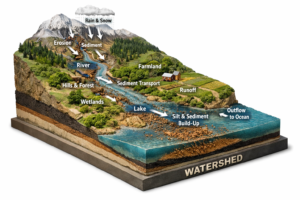
Why Are Some Watersheds More Sediment-Productive Than Others? An Explainable AI Approach
High-frequency turbidity sensors from 134 USGS stations, paired with RUSLE erosion estimates and explainable random forest models, map sediment yield and delivery ratios across the contiguous United States, revealing that human-modified landscapes dominate sediment transport efficiency while natural factors control total production, and highlighting priority sub-basins for targeted management in the Upper Mississippi and Chesapeake […]
Why Are Some Watersheds More Sediment-Productive Than Others? An Explainable AI Approach Read More »