Researchers conducted a detailed study using high-resolution regional climate modeling over Myanmar, providing crucial insights into future climate projections. Utilizing the Weather Research and Forecasting (WRF) model, the study enhances understanding of climate dynamics, vital for adaptation strategies in this vulnerable region.
Myanmar’s Complex Climate Landscape
Myanmar’s intricate geography and diverse climate patterns make it particularly susceptible to climate change impacts. The country’s topography, including the Ayeyarwady River system, the Bay of Bengal, and the Andaman Sea, results in varied precipitation patterns. Coastal areas receive substantial rainfall due to marine moisture sources, while the central Dry Zone remains comparatively arid. This variability poses significant challenges for reliable climate projections.
Myanmar ranks among the top ten countries most affected by climate extremes, including severe temperatures, droughts, cyclones, and extreme precipitation events. These challenges are compounded by the country’s limited economic capacity to prepare for and adapt to such events. The agricultural sector, a cornerstone of Myanmar’s economy, is particularly susceptible to climate change, impacting both the nation’s GDP and the livelihood of its population.
Understanding how anthropogenic climate change will affect Myanmar is crucial. While multiple climate model simulations are available from the Coupled Model Intercomparison Project (CMIP) Phase 6, they often lack the spatial resolution needed to capture Myanmar’s complex climate dynamics accurately. Previous studies have shown biases in temperature and precipitation projections over Myanmar, underscoring the need for more precise modeling approaches.
Refined Modeling Techniques
The researchers employed the Weather Research and Forecasting (WRF) model to conduct high-resolution regional climate simulations over Myanmar. This approach allowed them to simulate the present climate (1981–2010), as well as mid-century (2031–2060) and end-of-century (2071–2100) climates under different shared socioeconomic pathways (SSP2-4.5 and SSP5-8.5).
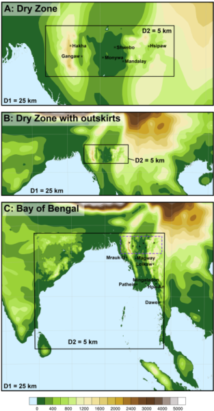
The study focused on improving the accuracy of climate projections by testing various domain settings, emphasizing the importance of large domains for accurately modeling climate and precipitation in Myanmar. The researchers validated the past climate simulations against station data and satellite-based products, demonstrating the model’s skill in representing Myanmar’s climate, albeit with some biases. Specifically, they identified a dry bias in the southern Ayeyarwady Delta and an underestimation of precipitation at the end of the rainy season in October.
The WRF model’s ability to simulate high-resolution climate dynamics is particularly valuable for regions like Myanmar, where complex topography and heterogeneous precipitation patterns demand detailed modeling. The study highlights the sensitivity of precipitation simulations to domain size, horizontal and vertical resolution, and other model parameters, underscoring the need for careful setup of high-resolution regional climate models.
Significant Findings
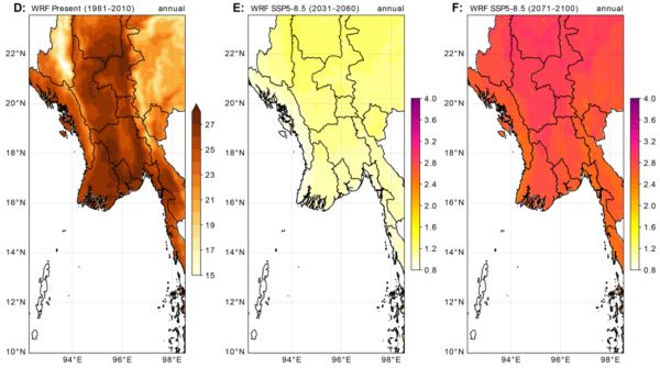
The research yielded significant insights into Myanmar’s future climate projections. The simulations indicate a distinct increase in 2m-temperature, with warming ranging from 0.9 to 2.7 °C by mid-century under SSP2-4.5, and up to 3.6 °C in the Dry Zone by the end of the century under SSP5-8.5. These projections suggest that April temperatures in the Dry Zone will increase disproportionately, while May will experience the strongest temperature rise in other scenarios.
Changes in precipitation patterns were also observed, with a non-significant wetting in the Dry Zone and significant drying in the Shan Hills and Tanintharyi Region under SSP2-4.5 and mid-century SSP5-8.5 scenarios. However, the end-of-century simulation under SSP5-8.5 projects a general wetting of the northwestern part, including the Dry Zone, by 40 to 60%. Despite an annual increase in precipitation, specific months like January, July, August, and November are expected to see reduced rainfall compared to the present climate.
Strategic Implications
This research provides a crucial knowledge base for developing adaptation strategies to mitigate the impacts of climate change in Myanmar. By offering high-resolution insights into future climate scenarios, policymakers and stakeholders can better prepare for the challenges ahead. The study’s findings underscore the importance of continued research and refinement of regional climate models to enhance their accuracy and reliability.
We thank the authors for their valuable contribution to the field of climate modeling. If you have insights or inputs to share, we encourage you to reach out and engage in this critical dialogue.
Reference: Messmer, M., González-Rojí, S. J., Nay Chi, M. A., & Leonard, S. (2026). High-resolution regional climate modeling over Myanmar using WRF: Historical validation and future projections under different shared socioeconomic pathways. PLOS Climate, 5(2 February), Article e0000820. DOI: https://doi.org/10.1371/journal.pclm.0000820