This pioneering research transforms subsidence risk assessment by merging InSAR satellite data with gravimetric mapping, offering a data-driven upgrade to outdated zoning practices and enhancing urban safety in groundwater-dependent regions, around 45 words of cutting-edge engineering insight.
Unraveling the Land Subsidence Crisis in Aguascalientes: Why It Demands Urgent Attention
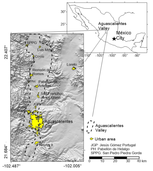
In the heart of Mexico’s Aguascalientes Valley, a silent yet destructive force is at work: land subsidence triggered by decades of intensive groundwater extraction. Home to Aguascalientes City with its 725,000 residents and nearby communities adding another 275,000, this region, located 430 km northwest of Mexico City, has been grappling with subsidence since the early 1970s. Driven by population growth, expanding agriculture, and industrial demands, over-pumping has depleted aquifers, causing the ground to sink at alarming rates and spawning surface faults that crack buildings and infrastructure.
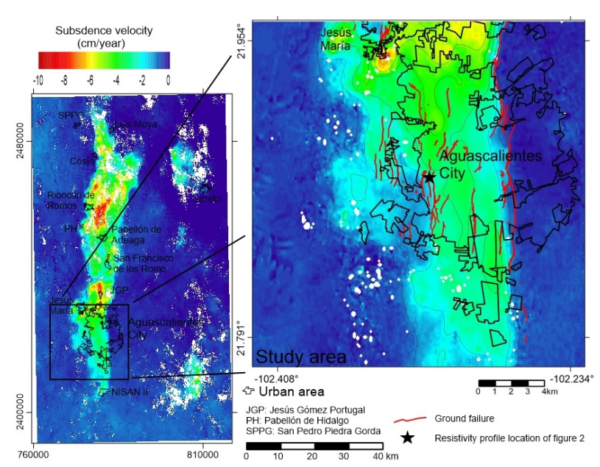
The first signs emerged in the late 1970s when a cluster of homes in Aguascalientes City developed linear cracks in walls and floors, initially mistaken for seismic activity from a geological fault. Since then, faults have proliferated across the valley, affecting urban centers like Cosio, San Francisco de los Romos, Jesús María, and smaller rural areas. Today, the subsiding zone spans about 942 km² with sinking rates up to 10 cm per year. Documented faults number at least 208, stretching a cumulative 290.678 km and damaging over 1,865 properties.
This isn’t just a geological curiosity, it’s a pressing engineering and societal challenge. Surface faulting inflicts severe structural damage on homes, roads, and utilities, sparking legal battles over affected properties and straining local governments. Even heritage sites, such as the Cathedral of Aguascalientes and the Museum of the Insurgency, have suffered cracks, threatening cultural landmarks. For engineers and planners, the stakes are high: unchecked subsidence risks escalating costs, safety hazards, and disrupted urban expansion.
Local authorities have responded with the State Urban Construction Code, mandating certified geologists for fault studies, municipal fault maps, distance-based risk zoning, and geophysical reports for building permits. Yet, the code falls short; it ignores regional subsidence, focusing solely on known faults; its zones (high-risk within 5 m, medium up to 200 m, low beyond) overlook differential sinking and future fault risks; study requirements are vague; and mandates apply even in stable areas like eastern Aguascalientes. These gaps leave zoning subjective, potentially exposing new developments to unseen dangers in this dynamic landscape.
Cutting-Edge Methodology: Harnessing InSAR and Gravimetry for Precision Subsidence Mapping
To bridge these deficiencies, the researchers deployed two powerful geophysical tools: Interferometric Synthetic Aperture Radar (InSAR) and gravimetric surveys, creating a robust framework for improved hazard zoning. InSAR, a satellite-based technique for detecting millimeter-scale surface deformations, was used to analyze a 2007–2011 time series from 34 ALOS satellite images across two frames on ascending track 191. Processing involved differential InSAR to generate 28 interferograms, followed by small baseline subset (SB) methods using ROI_PAC software. Topographic corrections were applied, and low-coherence pixels (below 0.7) were filtered out, yielding a detailed subsidence velocity map that highlights how geologic structures, like the valley’s graben filled with compressible alluvial sediments (silty sands and gravels), control deformation patterns.
Gravimetric surveys complemented this by mapping subsurface density variations. Using a Scintrex CG5 gravimeter, the team collected 339 ground measurements to compute the complete Bouguer anomaly across Aguascalientes City. This revealed an inverse relationship: higher anomalies signal thinner sediments, while lower ones indicate thicker, more subsidence-prone layers. Data inversion produced a bedrock model, constrained by well logs and outcrops, from which an isopach map of sediment thickness was derived by subtracting bedrock from surface elevations.
This integration innovates beyond traditional methods like electrical resistivity profiling, which struggles in complex or disturbed soils and often requires invasive trenching. By combining InSAR’s broad-scale velocity insights with gravimetry’s depth profiling, the study created a hazard factors array evaluating deformable sediments, ongoing subsidence, and fault presence. Spatial analysis then generated an objective zoning map, guiding tailored geotechnical studies, from standard soil tests in low-risk areas to advanced geophysical probes in high-risk zones.
Hard-Hitting Results and Key Conclusions from the Study
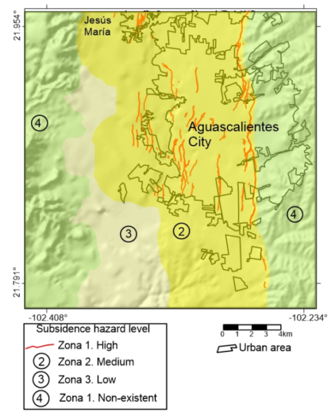
The InSAR velocity map pinpointed subsidence across 942 km² at rates up to 10 cm/yr, clearly delineating the graben’s boundaries as deformation hotspots. Gravimetric results produced a Bouguer anomaly map and sediment thickness model, confirming thicker deposits align with lower anomalies and heightened subsidence risk. The culminating hazard zoning map outlines four levels: Zone 4 (no hazard, negligible sediments and no subsidence—standard geotechnical studies suffice); Zone 3 (low hazard, deformable sediments present but no activity, add geological crack surveys); Zone 2 (medium hazard, active subsidence without faults, include geophysical fault detection); Zone 1 (high hazard, existing faults, add detailed differential subsidence assessments).
As the researchers conclude, “The zoning map of subsidence and surface faulting prone area is an important element in risk management of land subsidence and associated surface faults… The combination of both information sources, along with reliable subsurface geological information, allows us to determine in a comprehensible and sustainable way the subsidence hazard map for Aguascalientes.”
Broader Implications and Exciting Future Horizons
This methodology sets a blueprint for proactive subsidence management worldwide, with potential for real-time updates using ongoing satellite data to adapt to evolving groundwater dynamics.
Reference: Pacheco-Martínez, J., et al. (2015). Application of InSAR and gravimetric surveys for developing construction codes in zones of land subsidence induced by groundwater extraction: case study of Aguascalientes, Mexico. Proc. IAHS, 372, 121–127. doi:10.5194/piahs-372-121-2015.