Researchers have refined shipborne gravity data around Egypt, addressing inconsistencies in data collection to improve marine geoid models and oceanographic studies. By implementing a comprehensive crossover adjustment, they achieved enhanced precision in marine gravity field applications, particularly benefiting shallow water and coastal regions.
Enhancing Precision in Marine Gravity Measurements
Marine gravity measurements are vital for constructing the Earth’s gravity field, mapping seafloor topography, and supporting geophysical and exploration activities. Precision is crucial, especially for marine geoid refinement, which is essential for accurate oceanographic and geodetic studies. However, achieving high precision is challenging due to data collected over extended periods by different institutions using diverse instruments and methodologies.
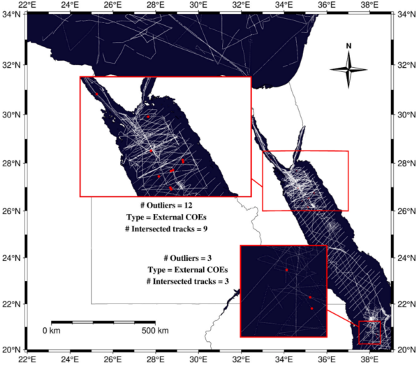
In Egypt, shipborne gravity measurements have been collected over the Mediterranean and Red Seas by various institutions. These datasets often exhibit inconsistencies due to differences in gravimeters, positioning accuracy, gravity reference systems, and applied corrections. Such inconsistencies can introduce significant biases, affecting the accuracy and reliability of the measurements. The challenge, therefore, lies in harmonizing these disparate datasets to produce a coherent and precise representation of the marine gravity field.
Previous studies have highlighted the importance of addressing these inconsistencies. For instance, Zaki et al. (2022) employed a cross-validation technique with kriging interpolation to refine shipborne gravity data around Egypt. This method involved validating the data against altimetric and global geopotential models, followed by a cross-validation process to detect and remove gross errors. While this approach improved data quality, it had limitations, such as eliminating duplicate points at ship track intersections and relying on interpolation to estimate predicted values. These limitations necessitated the exploration of more robust methodologies to ensure data consistency and accuracy.

The significance of resolving these inconsistencies cannot be overstated. Accurate marine gravity data are essential for enhancing the properties of gravity field models derived from satellite altimetry, particularly in shallow water and coastal regions where altimetric data are less accurate. By enriching the short-wavelength components of the gravity signals and filling the gaps between altimetric tracks, a more complete and precise representation of the regional marine gravity field can be achieved. This, in turn, provides a more reliable basis for marine geoid modeling, enabling more precise geoid height estimates crucial for converting GNSS-derived ellipsoidal heights into orthometric heights and improving the determination of dynamic ocean topography and ocean circulation.
Advanced Techniques Yield Improved Data Consistency
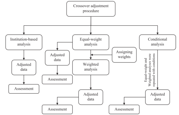
To address the inconsistencies in shipborne gravity data around Egypt, the researchers implemented a comprehensive crossover adjustment using the x2sys package from Generic Mapping Tools (GMT). This methodology involved detecting intersections among tracks in geographic coordinates and evaluating the crossover errors (COEs) at these intersections. COEs refer to the discrepancies between measurements taken at the same location, either within a single track (internal crossover) or between intersected tracks (external crossover).
The study explored three distinct adjustment approaches: institution-based, equal-weight, and weighted analyses. The institution-based approach categorized ship surveys according to data source, applying crossover analysis to each group separately. However, this technique yielded inadequate improvements due to a minimal number and uneven distribution of COEs. To overcome this limitation, the researchers implemented an equal-weight approach, assuming identical observational conditions and accuracy across all surveys. This method showed better performance, particularly when incorporating both internal and external COEs.
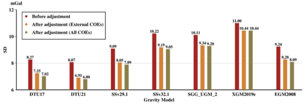
The most significant improvement was achieved with the weighted adjustment, which accounted for track-specific accuracy. This approach resulted in an optimal agreement of 5.10 mGal after adjustment. Additionally, a conditional analysis eliminating COEs beyond ±50 mGal led to further refinement, decreasing discrepancies at intersections to 4.62 mGal with a 9.41% gain in internal agreement. Validation against altimetric gravity models and global geopotential models (GGMs) demonstrated improvement in external alignment, with residual standard deviation reductions of up to 15.99% and 16.63% corresponding to external COEs and all COEs adjustment, respectively.
The implications of these findings are profound. The optimized shipborne gravity data support a wide range of geomatics applications, including precise marine geoid modeling and better determination of dynamic ocean topography and ocean circulation. By significantly reducing systematic errors and improving internal consistency, the adjusted data enhance the accuracy of the marine gravity field derived from satellite gravimetry or altimetry. This advancement is particularly beneficial in regions where altimetric data are less reliable, such as shallow seas and coastal zones.
Looking ahead, the researchers emphasize the potential for further refinement and application of these methodologies. The weighted adjustment approach, in particular, offers a robust framework for improving the quality of shipborne gravity data, paving the way for more accurate and reliable geomatics applications. As the field continues to evolve, the integration of advanced technologies and methodologies promises to unlock new possibilities for understanding and modeling the Earth’s gravity field.
In conclusion, this study marks a significant step forward in optimizing shipborne gravity data, offering valuable insights and methodologies for enhancing the precision of marine gravity field applications. We extend our gratitude to the authors for their contributions and encourage readers to explore the full potential of these advancements in geomatics.
Reference: Mahmoud Abulkhair, Ahmed Zaki, Ahmed Elhadary, Basem Elsaka, Mostafa Rabah, Optimizing shipborne gravity data around Egypt for enhanced geomatics applications, The Egyptian Journal of Remote Sensing and Space Sciences, 2026. DOI: https://doi.org/10.1016/j.ejrs.2026.01.010