This study employs Google Earth Engine and Landsat 7 imagery alongside random forest classification to analyze multitemporal trends in oxbow lake area, water types, and hydrologic connectivity, providing insights into ecohydrological processes and fish habitat availability in data-scarce tropical river systems such as Bolivia’s Beni River.
Challenges in Floodplain Dynamics Monitoring
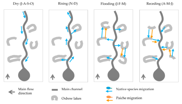
Meandering river floodplains, such as those along Bolivia’s Beni River, feature dynamic ecosystems where oxbow lakes form through channel cutoffs and evolve over time. These lakes serve as aquatic habitats influenced by hydrologic connectivity, primarily driven by overbank flows during flood pulses. This connectivity enables fish to migrate between the main channel and floodplains for spawning, feeding, and shelter, impacting fish abundance and the livelihoods of local fishing communities. High recruitment rates often follow extensive floods, increasing catches in subsequent years, while low-flow periods concentrate fish for harvesting.
Water turbidity from suspended sediments adds complexity. In sediment-laden rivers like the Beni, turbidity affects light penetration, altering predator-prey dynamics and favoring detritivorous species in murky waters. Monitoring these processes in remote, data-scarce regions is challenging. Field studies provide detailed insights into individual lakes but are limited by cost and scale. Prior remote sensing efforts in the Amazon relied on high-resolution imagery, restricting long-term analysis, while Beni-specific studies overlooked optical proxies and discharge data essential for turbid systems.
Without effective tools, alterations from climate change or human activities, such as shifting rainfall patterns or hydropower dams, could disrupt flood variability, reducing habitat availability and threatening ecological integrity. Preserving oxbow lake diversity is essential for maintaining river health, supporting biodiversity, and sustaining fisheries. This research uses satellite data to examine ecohydrological patterns, underscoring the need for strategies that protect connectivity and turbidity-driven habitats.
Remote Sensing Methodology for Ecohydrological Assessment
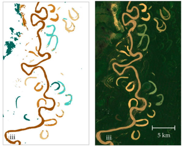
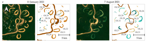
The study examined a 250 km reach of the Beni River, focusing on 40 oxbow lakes identified as fishing sites. Researchers processed Landsat 7 ETM+ imagery from 1999 to 2023 via Google Earth Engine, selected for its 30 m resolution, multispectral bands, and archive length. Preprocessing included cloud filtering (40% scene-wide, 20% per lake), outlier removal, and SLC-off stripe correction using a morphological mean filter.
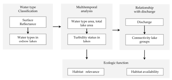
A random forest classifier was trained on an April 4, 2022, receding-water image to categorize land cover and water types: vegetation (NDVI > 0.6), exposed sand (NSI 0.5-0.75), and five water types based on spectral thresholds, turbid main channel (WTO), very turbid oxbow (WTA: red > 0.15), turbid oxbow (WTB: green/red < 1), chlorophyll-influenced (WTC: green/red > 1), and dark oxbow (WTD: green < 0.05). With 65% training and 35% validation points, the model showed 99% internal consistency, with near-infrared (31%) and red (20%) bands as primary features.
Multitemporal analysis tracked lake area and water type changes, associating them with lake age (from Google Earth Pro imagery), main channel distance, and orientation. Discharge data from Rurrenabaque (1989-2022, with gap estimates) and wind speeds (2010-2016) facilitated lake classification into three connectivity groups using Pearson correlations. Ecological relevance was evaluated based on fish preferences, associating turbid lakes with skin-covered species and clear lakes with scaled species.
This method combines optical proxies with hydrologic data for long-term, multi-lake assessments without extensive fieldwork, offering a framework applicable to similar turbid systems.
Research Findings and Outcomes
Water type classification indicated turbidity dynamics linked to lake age and main channel proximity, with seasonal shifts from low turbidity in early dry periods (June-July) to high during rising waters (September-October), influenced by wind resuspension and overflows. Multiannual trends showed high turbidity in 2000-2003, 2006, 2011, 2015-2016, and 2019-2021, while lake areas decreased in older, distant lakes due to infilling and increased in some through channel erosion.
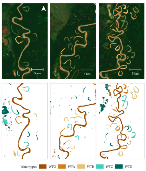
Discharge relationships classified lakes into groups: Group 1 (>0.4 correlation, 14 lakes, mostly recent and turbid) with frequent connectivity; Group 2 (0.1-0.4, 13 lakes) showing sediment settling; and Group 3 (≤0.1, 13 lakes, older and clear) connecting only during peaks. Total lake area was 53 km², with 22% turbid, 56% intermediate, and 22% clear, corresponding to 49 km² available habitat distributed as 28% in Group 1, 31% in Group 2, and 41% in Group 3.
The study concludes that “oxbow lake diversity and connectivity are essential for river ecological integrity,” with flooding enhancing habitat availability and stressing preservation of natural hydrologic variability.
Implications and Future Directions
This approach could support management in other floodplains, incorporating real-time data to predict habitat changes under climate influences.
We thank Lina G. Terrazas-Villarroel and her team for advancing ecohydrological research. As they state, “understanding the diversity of oxbow lakes dynamics provides valuable ecohydrological insights for river floodplain management.” Share insights or collaborate, contact via the paper’s details.
Reference: Terrazas-Villarroel, L.G.; Wenninger, J.; Heredia-Gómez, M.; van de Giesen, N.; McClain, M.E. Monitoring Oxbow Lakes with Remote Sensing: Insights into Turbidity, Connectivity, and Fish Habitat. Remote Sens. 2026, 18, 474. https://doi.org/10.3390/rs18030474.