Researchers have developed the Relay Residual Diffusion Probabilistic Model (RRDPM) to enhance global digital elevation model (DEM) resolution. This innovative approach improves detail recovery for land and seabed regions, offering significant advancements in fields that rely on precise topographical data for scientific and practical applications.
Overcoming Challenges in Global DEM Resolution
Global digital elevation models (DEMs) are essential for scientific research and various human activities, offering comprehensive representations of the Earth’s surface. They serve as foundational datasets across fields such as climate change, plate tectonics, natural hazard assessment, geomorphology, and resource exploration. High-resolution DEMs provide deeper insights into these areas, enabling more accurate modeling and predictions. Additionally, DEMs are crucial in socio-economic sectors, including urban planning, navigation, marine transportation, and geographic information systems (GIS) applications.
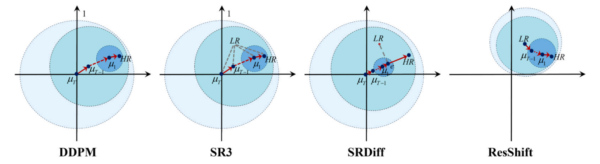
mean µt, and the radius denotes the variance ∑t). ResShift employs a residual diffusion paradigm that initiates the reverse diffusion process from the LR distribution,
resulting in a more accurate initial distribution and a more efficient inference procedure.
Despite their importance, acquiring comprehensive elevation data globally remains challenging, particularly for oceanic regions. Current open-access global DEMs, like those from the General Bathymetric Chart of the Oceans (GEBCO), are limited to a 15 arc-seconds resolution, approximately 450 meters. This limitation constrains the detail available for scientific and practical applications, especially in marine environments where bathymetric data is crucial.
The difficulty in obtaining high-resolution DEM data for oceanic regions is primarily due to the reliance on shipborne and mobile multi-beam echo sounding systems, which are time-consuming and costly. While satellite gravity measurements and remote sensing techniques offer alternative methods for estimating water depth, they have limitations. Satellite gravity measurements provide only a 1 arc-minute spatial resolution, while remote sensing is restricted by the weak penetration of electromagnetic waves in water, limiting its use to shallow coastal areas.
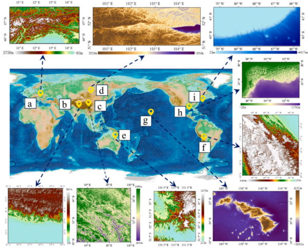
(f) Bolivia, (g) Hawaii, (h) Gulf of Mexico, and (i) eastern continental shelf of the United States, where (a) to (f) are land areas and (g) to (i) are oceanic areas.
In recent years, the field of DEM super-resolution has rapidly advanced, driven by deep learning techniques. Single image super-resolution (SISR) methods have been developed to learn the mapping relationship between low-resolution (LR) and high-resolution (HR) images, effectively overcoming the limitations of measurement devices. These methods reconstruct HR images from LR inputs, achieving excellent results in enhancing DEMs. However, traditional super-resolution approaches often rely on simulated degradation data, which may not accurately reflect real-world conditions.
Introducing the Relay Residual Diffusion Model
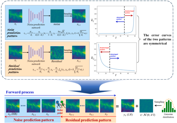
The Relay Residual Diffusion Probabilistic Model (RRDPM) marks a significant innovation in DEM super-resolution. This model leverages diffusion model principles to transform distributions between high- and low-resolution DEMs through a series of steps. The RRDPM introduces two types of inherently indivisible sampling equations, each with distinct advantages, integrated using a “relay race” approach. This method allows for efficient sampling, significantly reducing the steps required to complete the diffusion process.
One of the key innovations of the RRDPM is its departure from the conventional downsampling-super-resolution paradigm. Instead of relying on simulated degradation data, the model utilizes paired datasets of global 15 arc-second and local 3 arc-second DEMs. This approach enables the RRDPM to be trained and tested in real-world situations, enhancing its practicality and applicability.
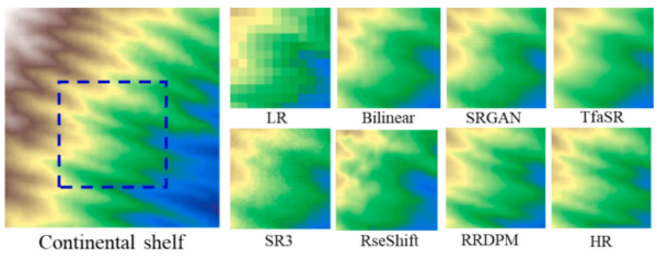
The experimental results of the RRDPM are noteworthy. The model reduces the root mean square error (RMSE) by 20.73% for land regions and 22.77% for seabed regions. Additionally, it improves the peak signal-to-noise ratio (PSNR) by 2.23 dB and 2.34 dB for land and seabed regions, respectively. These improvements represent significant advancements in the current state of global DEM detail recovery.
The RRDPM’s success is attributed to several factors. First, the model’s target distribution for the forward process is defined as P(LR) + N(0, k²I), requiring only 50 steps or fewer to complete the diffusion process. This efficiency is achieved through the relay sampling method, which completes the sampling process in two stages: residual prediction and noise prediction. The model’s performance is optimized by recognizing that a single pattern performs differently at each timestep, allowing for a more tailored approach to sampling.
Furthermore, the RRDPM incorporates a residual/noise prediction network, SDU-net, designed based on Swin Transformer blocks and densely connected blocks. This architecture enables the model to learn features from both local and global information, effectively reducing computational complexity while maintaining high performance.
The implications of the RRDPM for the field of DEM super-resolution are profound. By enhancing the resolution and detail of DEMs, the model supports the “Seabed2030” initiative, which aims to facilitate the complete mapping of the world’s oceans by 2030. The RRDPM’s ability to improve DEM detail recovery has the potential to transform various applications, from scientific research to practical industries, by providing more accurate and detailed topographical data.
Reference: Jianbing Chen, Ziyin Wu, Fanlin Yang, Mingwei Wang, Xianhai Bu, Xiaodong Cui, Jihong Shang, Dineng Zhao, Jieqiong Zhou, Yang Liu, “RRDPM: Relay residual diffusion probabilistic model for global typical land and seabed DEM super-resolution,” International Journal of Applied Earth Observation and Geoinformation, 2026. DOI: https://doi.org/10.1016/j.jag.2025.105031