Researchers have introduced a novel ensemble learning framework utilizing UAV imagery and soil auxiliary data to enhance soil salinity estimation. This approach aims to improve agricultural sustainability by offering more precise and efficient soil quality assessments, addressing the challenges of traditional monitoring methods.
The Global Threat of Soil Salinization
Soil salinization is a pressing global issue, threatening land sustainability and food security. Characterized by the excessive accumulation of soluble salts in the soil, this process can degrade soil structure, reduce nutrient availability, and hinder plant growth. It is estimated that over 1 billion hectares of land worldwide are affected by soil salinization, impacting more than 100 countries. This situation is exacerbated by climate change, which accelerates salinization through increased evaporation and altered precipitation patterns. The resulting effects on agricultural productivity are severe, leading to lower crop yields, diminished soil fertility, and reduced biodiversity, which adversely impact millions of farmers’ livelihoods and the overall stability of food systems.
Traditional methods for monitoring soil salinity content (SSC) rely heavily on field sampling and laboratory analysis. While these methods provide precise data for specific sites, they are time-consuming, labor-intensive, and costly, making high-density sampling over large regions challenging. Additionally, the inherent spatial variability in SSC means that a limited number of sampling points may not adequately represent the SSC distribution over large areas. Optical remote sensing (ORS) offers a high spatial resolution alternative for assessing soil conditions across large areas, but traditional ORS techniques, such as airborne and satellite sensors, often suffer from limited spatial resolution and can be impacted by cloud cover and adverse weather conditions.
Advancing Soil Salinity Estimation Techniques
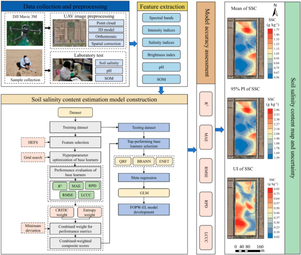
To address these challenges, the research team proposed a feature-optimized and performance-weighted ensemble learning (FOPW-EL) framework for estimating SSC using UAV imagery and soil auxiliary information. This approach integrates hybrid embedded feature selection (HEFS) to extract sensitive features and CRITIC-Entropy combined weighting (CECW) to identify optimal base learners. The FOPW-EL model leverages the high spatial resolution of UAV imagery, which allows for the detection of subtle SSC variations and small-scale features, while integrating soil auxiliary information such as soil organic matter (SOM) and pH to enhance the accuracy of SSC estimation.
The ensemble learning framework is designed to overcome the limitations of traditional machine learning models, which may not excel in every situation. By combining multiple base learners, the FOPW-EL model effectively uncovers underlying spectral patterns related to SSC, potentially surpassing the accuracy of conventional machine learning approaches. The model’s design considers the varying contributions of each base learner to the final predictions, ensuring that the ensemble learning model’s performance is not compromised by the errors of less accurate base learners.
Study Outcomes and Insights
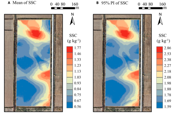
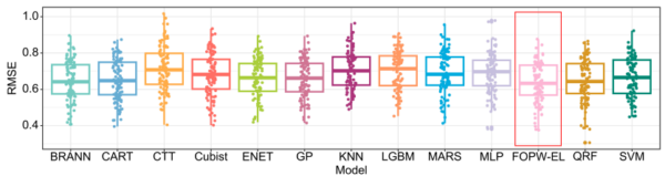
The results of this study demonstrate that the FOPW-EL model substantially outperformed all other models tested. The model achieved average validation metrics with a coefficient of determination (R²) of 0.752, a ratio of prediction to deviation (RPD) of 1.744, and a linear correlation consistency coefficient (LCCC) of 0.792. Additionally, the model exhibited low prediction uncertainty, with the global uncertainty index consistently below 0.39.
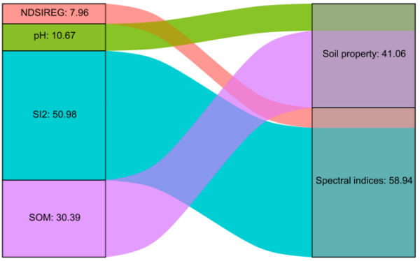
Key findings from the feature importance assessment revealed that spectral indices played a crucial role in SSC modeling, contributing 58.94% to the overall model. The study identified SOM, salinity index (SI2), normalized difference salinity red edge index (NDSIREG), and pH as the most sensitive feature variables, with SI2 showing a strong positive correlation with SSC. In contrast, SOM and pH values exhibited significant negative correlations with SSC.
Future Directions in Soil Quality Monitoring
This research holds considerable promise for providing accurate, cost-effective, and efficient SSC estimation, which could greatly aid in soil quality monitoring and sustainable agricultural practices. The integration of UAV imagery with soil auxiliary information represents a significant advancement in the field of soil salinity estimation, offering a more reliable and comprehensive approach to managing saline-alkali land.
We thank the authors for their valuable contribution to this field. For those interested in exploring this innovative approach further or sharing insights, we encourage you to reach out and engage with the research community.
Reference: Wang L, Yang J, Wu S, Xia L, Lu M, Li W, Wu W, Zha Y, Yang P. A Feature-Optimized and Performance-Weighted Ensemble Learning for Estimating Soil Salinity Using UAV Imagery and Soil Auxiliary Information. J. Remote Sens. 2026;6:Article 0805. DOI: https://doi.org/10.34133/remotesensing.0805