GlobalBuildingAtlas introduces an open dataset with global coverage of 2.75 billion building polygons, 3 m resolution height maps, and LoD1 3D models, derived from satellite imagery, offering enhanced detail for urban analysis, planning, and monitoring progress toward the UN’s Sustainable Development Goals.
The Need for Detailed Global Building Information
Buildings serve as the foundation of urban environments, influencing human life and city functionality. The United Nations reports that over 50% of the global population resides in cities, with projections reaching nearly 70% by 2050. This urbanization presents opportunities for community connectivity but also challenges such as inequalities, urban poverty, inadequate infrastructure, air pollution, and limited public spaces. The UN’s 11th Sustainable Development Goal (SDG 11) addresses sustainable cities and communities.
Monitoring SDG 11 relies on indicators like the ratio of land consumption to population growth (Indicator 11.3.1), based on built-up areas. However, this 2D metric can lead to incomplete interpretations, as cities are three-dimensional. Without height data, areas with similar footprints, such as dense informal settlements and multi-story neighborhoods, appear equivalent, despite differences in spatial use, social conditions, and infrastructure. Building height information enables volumetric perspectives, supporting urban planning, infrastructure management, and policy decisions, particularly in regions with limited resources.
Existing global building products have limitations. Raster-based datasets, such as World Settlement Footprint 3D and Global Human Settlement Layers, provide broad coverage at resolutions of 90 m to 250 m, restricting detailed applications. Instance-level products, like Microsoft’s 1.4 billion footprints and 3D-GloBFP’s 1.7 billion, offer building-specific data but lack full global completeness, missing significant portions of the estimated 4 billion buildings worldwide per UN Habitat. Many depend on inconsistent data sources, affecting scalability and timeliness in evolving urban areas.
Pipeline for Generating Global Building Data
The GlobalBuildingAtlas (GBA) dataset was developed using a machine learning pipeline based exclusively on PlanetScope Surface Reflectance (PSR) optical satellite imagery, ensuring consistency and scalability. Created by researchers at the Technical University of Munich, the approach avoids ancillary data for global applicability.
Data acquisition divided the Earth’s surface into 0.2° × 0.2° grids, targeting built-up areas from the Global Urban Footprint. Approximately 800,000 PlanetScope scenes from 2019 (supplemented by 2018) were selected, with cloud cover below 10%, and mosaicked using quality masks.
Building polygons were generated from training data of 142,722 PSR patches across 107 regions (92 urban, 15 non-urban). A UPerNet model with ConvNeXt-Tiny backbone produced binary masks, refined by a regularization network to address noise and merging. Polygons were created via GDAL contour tracing, simplified, and filtered using a dilated World Cover built-up mask (250 m window) to remove false positives.
Heights were estimated monocularly using an HTC-DC Net with EfficientNet-B5 backbone, trained on 231,656 patches from 168 regions with LiDAR-derived normalized digital surface models as references, following a classification-regression method.
GBA.Polygon fused generated polygons with open sources (OSM, Google Open Buildings, Microsoft, CLSM) based on quality. GBA.Height provides raster maps, and GBA.LoD1 assigns median heights to polygons for vector models.
Results and Key Findings
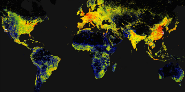
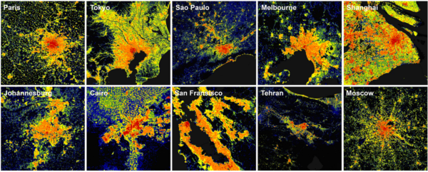
GBA.Polygon includes 2.75 billion buildings, surpassing existing datasets by more than 1 billion. GBA.Height achieves 3 m × 3 m resolution, with volume RMSEs ranging from 38.0 to 580.0 m³ per 100 m² across continents.
GBA.LoD1 covers 2.68 billion instances with predicted heights (97% completeness), with height RMSEs from 1.5 to 8.9 m across continents. These products support volumetric analysis for urban insights.
Implications and Future Directions
GlobalBuildingAtlas enables geospatial analyses, including improved population distribution mapping and SDG 11 monitoring. As noted, it “unlocks unprecedented geospatial analysis possibilities.”
We thank Xiao Xiang Zhu and the team for this contribution. For input or collaboration, contact via the GitHub repository.
For details, see: Zhu, X. X., Chen, S., Zhang, F., Shi, Y., and Wang, Y.: GlobalBuildingAtlas: an open global and complete dataset of building polygons, heights and LoD1 3D models, Earth Syst. Sci. Data, 17, 6647–6668, https://doi.org/10.5194/essd-17-6647-2025, 2025.