This study develops a framework combining UAV photogrammetry with multi-layered perception methods to examine blue-green infrastructure’s effects on visual attention, preferences, and cognitive interpretations in historic urban areas, offering replicable tools for heritage-sensitive planning and evaluation.
Underexplored Visual Role of Blue-Green Infrastructure in Historic Urban Areas
Historic urban areas (HUAs) serve as repositories of cultural heritage, including cities, towns, and districts that integrate natural and built environments. Defined in 1987 by the Washington Charter, these spaces preserve histories while supporting activities such as tourism and commerce. They increasingly incorporate blue-green infrastructure (BGI), such as rivers, wetlands, parks, and greenery, which provide ecological benefits including flood control, biodiversity support, and improved well-being.
In examples like China’s Jiangnan water-town tradition, BGI contributes to cultural identity through canal corridors, bridges, and alleys framed by greenery, maintaining a traditional aesthetic. Research has addressed BGI’s integration with historic structures and its contributions to resilience, but its influence on visual perception in HUAs remains underexplored. Visual perception is key to assessing these areas’ cultural and environmental quality, affecting responses like beauty and belonging.
Approaches to visual perception in HUAs include perception-based studies on user differences influenced by demographics and emotional responses, and geo-spatial methods using GIS, 3D modeling, or street-view analysis for visibility data. Perception-based methods capture subjective aspects but lack spatial precision, while geo-spatial techniques provide objectivity without emotional or cultural context. In heritage contexts with rising ecosystem solutions, bridging these approaches supports effective planning.
This research addresses gaps by examining BGI exposure measurement from pedestrian views, integrated methods for visual impact assessment, and BGI’s effects on attention, evaluations, and interpretations across experts and the public. These insights aid engineers and planners in designing HUAs that balance cultural legacies with modern requirements.
Integrated Framework: UAV Photogrammetry and Layered Perception Analysis
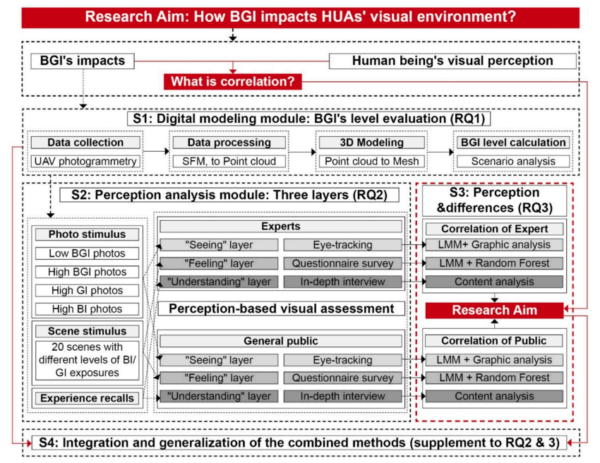
The research framework combines digital spatial modeling with perception methods across three layers: seeing (physiological attention), feeling (affective preferences), and understanding (cognitive interpretations). This approach addresses methodological separations, providing a replicable tool for heritage assessments.
The case study examines Pingjiang Road in Suzhou, China, a protected historic street with Jiangnan water-town features including canals, bridges, and traditional facades. The southern segment was selected for its varied BGI, including a restored waterway.
Digital modeling used UAV (DJI Phantom 4 Pro) and ground-level photography from December 2024 to create a 3D semantic mesh via Structure-from-Motion and Multi-View Stereo. Surfaces were labeled as blue infrastructure (BI, e.g., water), green infrastructure (GI, e.g., vegetation), or other. Pedestrian viewpoints at 1m intervals simulated fields of view, calculating BGI exposure. Thresholds categorized GI (high ≥25%, medium 15-24.9%, low 5-14.9%, very low <5%) and BI (high ≥7.5%, medium 4.5-7.4%, low 1.5-4.4%, very low <1.5%), identifying 15 typologies for scene selection. Unity simulations validated results.
Perception experiments included 80 participants per group (experts: architects/landscape architects; public: non-specialists), refined to 40 for eye-tracking and 20 for interviews, all aged ≤40 with suitable vision.
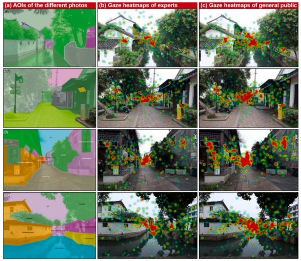
The seeing layer applied eye-tracking to 24 static images (20 modeled, 4 added), displayed for 20s. Areas of interest (AOIs) covered historical elements, GI, and BI. Heatmaps and fixation durations were analyzed using linear mixed models (LMMs) for BGI effects.
The feeling layer used questionnaires rating scenes on a 1-5 scale across historical atmosphere, spatial aesthetics, and functionality. Descriptive statistics, LMMs, and Random Forest (RF) assessed BGI influences.
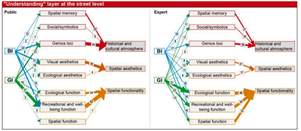
The understanding layer involved semi-structured interviews, coded to map pathways from BGI to themes.
Integration connected perceptual data to street-level exposure for assessments and predictions, supporting engineering applications.
This cross-method, cross-layer, cross-group framework embeds UAV data in perception analysis, facilitating high-resolution evaluations in heritage settings.
Key Findings and Insights
Spatial modeling identified heterogeneous BGI patterns: high BI along canals, high GI in alleys, combined high at intersections, low in commercial zones.
In the seeing layer, heatmaps indicated moderate BGI attraction, with historical AOIs dominant (experts: 0.64s; public: 0.78s). LMMs confirmed cultural salience, with BI reducing historical focus (-0.124 coef) and GI self-reinforcing. Public attention to cultural points was lower.
For the feeling layer, high BGI scenes scored 4.73-4.87, low below 4.0. LMMs and RF showed GI’s broad impact (experts: ecological aesthetics 0.23 coef), BI’s targeted effects (public: visual aesthetics 0.25 coef). GI averaged 0.63 importance in experts, BI stronger for public aesthetics and genius loci.
The understanding layer yielded 620 pathways: public prioritized recreational/well-being (60), genius loci (44), visual aesthetics (39); experts ecological function (49), recreational/well-being (39), spatial function (33). GI was slightly favored over BI.
Street integration indicated high BGI diversifying attention, elevating preferences (4.6-4.8 vs. 3.8-4.0), with southern segments highest.
As quoted: “BGI enhances perceptual diversity, visual preference evaluation, and cognitive engagement across both groups.”
Practical Applications and Future Directions
This framework enables BGI designs in HUAs that balance ecology and heritage. Future research could expand demographics, incorporate mobile eye-tracking, or apply to global contexts.
Reference: Peng, Y., Li, W., Nijhuis, S., Yu, Y., & Wu, Z. (2026). Seeing heritage through green and blue: Assessing the visual influence of blue-Green infrastructure (BGI) in historic urban areas (HUAs). Environmental Impact Assessment Review, 118, Article 108301. https://doi.org/10.1016/j.eiar.2025.108301