This study examines UAV-based LiDAR technology for measuring crop characteristics such as canopy height and leaf area index under day and night conditions. It highlights the potential of LiDAR to enhance precision agriculture by overcoming limitations of traditional remote sensing methods, offering reliable data collection flexibility.
Understanding the Importance of Crop Measurement
In precision agriculture, managing crop growth is essential. Biophysical parameters like canopy height (CH) and leaf area index (LAI) are critical for modeling processes such as photosynthesis, evapotranspiration, and carbon cycling. Traditionally, these measurements have been labor-intensive, requiring in-situ assessments that are both time-consuming and often impractical over large areas. This has led to an increasing reliance on remote sensing technologies, which offer a more efficient alternative.
However, conventional remote sensing methods, particularly those using passive optical sensors, come with their own set of challenges. They are highly dependent on specific light conditions, such as cloud-free skies and solar noon, to ensure accurate data collection. This dependency limits the flexibility of data acquisition and can introduce variability in the results. Furthermore, these sensors struggle with issues like over-saturation in dense canopies, making them less reliable for certain types of vegetation analysis.
LiDAR technology offers a promising solution to these challenges. Unlike passive sensors, LiDAR is an active remote sensing method that does not rely on sunlight, allowing for data collection under a variety of light conditions, including nighttime. This flexibility is particularly beneficial for capturing detailed 3D representations of crop structures, which can greatly enhance the accuracy of CH and LAI measurements. Despite these advantages, the application of LiDAR in agriculture has been limited, with most studies focusing on forestry rather than crop fields.
Innovative Approach to Crop Analysis
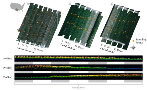
The study conducted by Flynn et al. assessed the effectiveness of UAV-based LiDAR in measuring CH and LAI for corn crops under different light conditions. The research was carried out at the USDA-ARS Grassland Soil and Water Research Laboratory and the Texas AgriLife Blackland Research Center in Temple, Texas. The experiments involved multi-planting date corn fields with varying topographies and tillage practices.
To achieve their objectives, the researchers employed a Velodyne VLP-16 Puck Lite laser scanner mounted on a DJI M600 Pro hexacopter. This setup allowed for the collection of detailed LiDAR data, capturing up to 300,000 points per second with high accuracy. The flights were conducted both during the day and at night to evaluate the impact of light conditions on data quality.
The LiDAR data was processed using a cloth simulation filter (CSF) to distinguish between ground and vegetation points, which was crucial for accurate CH calculations. For LAI estimation, the study utilized laser penetration and intensity-based indices, which are less affected by the saturation issues common in optical remote sensing. This approach enabled the researchers to compare LiDAR-derived measurements with traditional in-situ methods, providing a robust validation of their techniques.
Key Findings and Conclusions
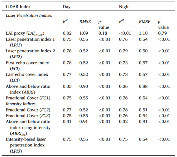
The findings of the study demonstrated a high correlation between LiDAR-based and in-situ measurements for both CH and LAI. Specifically, CH measurements showed a correlation coefficient (R²) of ≥ 0.91 with a root mean square error (RMSE) of ≤ 15.43, while LAI measurements had an R² of ≥ 0.77 and an RMSE of 0.52. These results indicate that LiDAR can reliably replicate traditional measurement methods.
The study found minimal differences in CH measurements between day and night flights, with a Δ R² of ≤ 0.01, suggesting high replicability regardless of light conditions. However, LAI measurements exhibited slightly more variability (Δ R² ≤ 0.05), which the researchers attributed to changes in leaf turgor between day and night.
Future Prospects and Applications
This research lays a solid foundation for the broader adoption of UAV-based LiDAR in precision agriculture, particularly in environments where traditional remote sensing methods fall short. By demonstrating the reliability and flexibility of LiDAR under various light conditions, the study opens up new possibilities for continuous crop monitoring and management.
The authors suggest that future research could further explore the integration of LiDAR with other remote sensing technologies to enhance data accuracy and utility. This could lead to even more sophisticated models for predicting crop performance and optimizing agricultural practices.
Reference: Flynn, K. C., Baath, G. S., Sapkota, B. R., & Smith, D. R. (2026). Assessing day and night UAV-based estimates of crop characterization using LiDAR. Smart Agricultural Technology, 13, 101805. DOI: https://doi.org/10.1016/j.atech.2026.101805