Researchers have developed a framework to georeference historical flood maps, unlocking decades of valuable data. This advancement allows for a detailed analysis of flood hazard changes, providing insights into urban flood resilience and informing future floodplain management strategies, with significant implications for urban planning and policy decisions.
Historical Flood Data: Challenges and Opportunities
Flooding is a major natural hazard causing extensive damage globally and in the United States. Despite its increasing frequency and severity, historical flood records for U.S. urban areas are often fragmented and limited. This lack of comprehensive data has constrained longitudinal studies, crucial for understanding floodplain dynamics and informing urban planning and resilience strategies. The scarcity of spatially and temporally detailed flood data has hindered efforts to assess changes in flood hazards over time, leaving a gap in understanding urban evolution in response to flooding threats.
The United States National Flood Insurance Program (US-NFIP) has consistently provided data, producing Flood Insurance Rate Maps (FIRMs) since the 1970s. These maps delineate Flood Hazard Areas (FHAs) with a 1% annual chance of flooding, known as the 100-year floodplain, and since the late 1980s, they also include the 0.2% annual chance floodplain, or the 500-year floodplain. By 2020, over $10.6 billion USD had been invested in developing and maintaining these maps, underscoring their potential value. However, historical FIRMs, especially those created before digital mapping technologies around 2008, lack georeferencing information, complicating integration with modern geospatial data for comprehensive flood hazard analyses.
Manual georeferencing of these historical maps is labor-intensive and requires significant GIS expertise, limiting the scope of studies that can incorporate this valuable data. The absence of a systematic approach to automate georeferencing of historical FIRMs has left a wealth of high-quality flood data largely untapped. This limitation has motivated researchers to explore innovative methods to automate the extraction and georeferencing of floodplain data from historical FIRMs, aiming to bridge the gap between past and present flood hazard assessments.
Previous studies have demonstrated the potential of historical FIRMs to inform floodplain management and policy decisions. For instance, analyses of localized areas have shown that policies restricting development within the 100-year floodplain can effectively reduce exposure in those areas, but may inadvertently increase exposure in less regulated zones, such as the 500-year floodplain. Despite these insights, the limited spatial and temporal scope of past studies has highlighted the need for automated data extraction techniques that can handle large-scale, longitudinal flood hazard analyses.
Advanced Framework for Flood Hazard Analysis
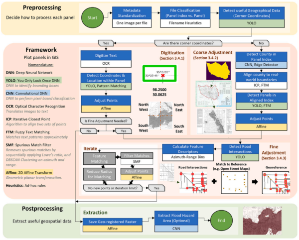
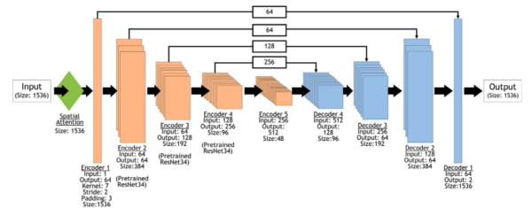
To address the challenges posed by historical flood data, researchers have developed a comprehensive framework that leverages advanced technologies in photogrammetry, geomatics, and artificial intelligence. This framework is designed to automatically georeference historical FIRMs, enabling the extraction of floodplain data with high accuracy and efficiency. The core of this framework involves deep learning techniques for image processing, specifically tailored to identify and classify features within FIRM panels.
The framework employs two primary deep learning tasks: pixel classification and position estimation. Pixel classification, or semantic segmentation, is achieved through a series of Convolutional Neural Networks (CNNs) structured as U-NETs with RESNET backbones and Spatial Attention mechanisms. This architecture allows for precise identification of floodplain boundaries and other critical map features. For position estimation, the framework utilizes the You Only Look Once (YOLO) models, renowned for their speed and accuracy in object detection tasks.
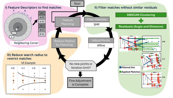
A key innovation of this research is the systematic validation of the georeferencing framework, ensuring that the extracted data accurately reflects the historical floodplain extents. The researchers report a median georeferencing residual of 23.1 meters, which is smaller than the accuracy of the validation dataset, demonstrating the reliability of their approach. This level of precision is crucial for conducting meaningful longitudinal analyses of flood hazard changes.
The framework’s utility is exemplified through case studies of three flood-prone watersheds in Greater Houston: Brays Bayou, Hunting Bayou, and Cypress Creek. These case studies reveal significant changes in flood hazard over time, with floodplain expansion leading to a dramatic increase in population exposure and vulnerability of critical infrastructure. In some areas, population exposure to flood hazards is estimated to have risen by up to 635%, highlighting the urgent need for updated flood management strategies.
The implications of this research are profound, offering a new avenue for the widespread assessment of longitudinal flood hazards. By unlocking the rich historical data contained within FIRMs, the framework provides valuable insights into the evolution of flood risks and resilience in urban areas. This information is essential for informing policy decisions, guiding urban development, and enhancing flood resilience in the face of climate change and increasing urbanization.
The authors of this study have laid the groundwork for future research, suggesting that the framework could be expanded to incorporate additional data sources and refined to improve its accuracy and applicability. The integration of this framework with modern geospatial data holds the potential to transform flood hazard assessments, enabling more informed decision-making and proactive measures to mitigate flood risks.
In conclusion, this research represents a significant advancement in the field of flood hazard analysis, offering a powerful tool for understanding and managing the complex dynamics of urban floodplains. We extend our gratitude to the authors for their innovative contributions and encourage readers to explore the potential applications of this framework in their own flood resilience efforts.
Reference: Francisco Haces-Garcia, Craig L. Glennie, Hanadi S. Rifai, Vedhus Hoskere, The longitudinal assessment of flood hazard in cities: Unlocking the floodplain record of Houston, TX, USA, Journal of Hydrology: Regional Studies, 2026. DOI: https://doi.org/10.1016/j.ejrh.2026.103113