Lars Langhorst

Regenerative Wind Farming Using Vertical-Axis Turbines

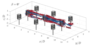
Enhancing Wake Recovery in Dense VAWT Arrays Explore this experimental study on regenerative wind farming, where vertical-axis wind turbines in a high-density grid employ vortex generator modes via blade pitching to entrain momentum, yielding available power increases of up to 6.4 times for downstream rotors and advancing efficiency in wind energy systems. Addressing Wake Losses […]

Regenerative Wind Farming Using Vertical-Axis Turbines Read More »

Visual Impact of Blue-Green Infrastructure in Historic Urban Areas

This study develops a framework combining UAV photogrammetry with multi-layered perception methods to examine blue-green infrastructure’s effects on visual attention, preferences, and cognitive interpretations in historic urban areas, offering replicable tools for heritage-sensitive planning and evaluation. Underexplored Visual Role of Blue-Green Infrastructure in Historic Urban Areas Historic urban areas (HUAs) serve as repositories of cultural

Visual Impact of Blue-Green Infrastructure in Historic Urban Areas Read More »

Land Subsidence in Aguascalientes, Mexico: Innovative InSAR and Gravimetric Surveys

This pioneering research transforms subsidence risk assessment by merging InSAR satellite data with gravimetric mapping, offering a data-driven upgrade to outdated zoning practices and enhancing urban safety in groundwater-dependent regions, around 45 words of cutting-edge engineering insight. Unraveling the Land Subsidence Crisis in Aguascalientes: Why It Demands Urgent Attention In the heart of Mexico’s Aguascalientes

Land Subsidence in Aguascalientes, Mexico: Innovative InSAR and Gravimetric Surveys Read More »

Annual Memory in the Terrestrial Water Cycle 

This research refines a GIS-based toolbox by integrating high-resolution land-cover data and new models for afforestation and riparian forest buffers, applied to six European river basins to map suitable locations for large-scale nature-based solutions that reduce hydrometeorological risks and highlight opportunities for combined implementations. Addressing the Escalating Hydrometeorological Risks with Nature-Based Solutions Climate change is

Annual Memory in the Terrestrial Water Cycle  Read More »

3d historical city

Reconstructing Historical 3D City Models from Maps

Researchers at TU Delft present a methodology to generate plausible 3D city models from scanned historical maps, using alignment, procedural modeling, and height inference to minimize manual work and support applications like population estimation, disease mapping, and spatial simulations for European cities between 1700 and 2000. Challenges in Historical 3D City Modeling and Their Significance

Reconstructing Historical 3D City Models from Maps Read More »

transport optimisation with data driven simulation

Optimizing Transportation Through Cross-Sector Data-Driven Simulation

Explore an integrated framework that combines data-driven modeling with simulation technologies to facilitate collaboration between small agriculture and forestry businesses, improving resource utilization and addressing seasonal demand variations in transportation management, offering practical insights for enhanced efficiency in developing EU economies like Latvia. Addressing Seasonal Challenges in Agricultural and Forestry Transportation Small enterprises in agriculture

Optimizing Transportation Through Cross-Sector Data-Driven Simulation Read More »

Insar for landslide detection with a bridge

Analyzing Landslide-Bridge Interactions Through InSAR and Numerical Modeling

This study integrates InSAR satellite monitoring with three-dimensional numerical modeling to examine the effects of a landslide on a bridge, addressing the one-dimensional limitations of InSAR through modeling-derived displacement directions and validating simulations with observed surface deformations for improved understanding of infrastructure vulnerabilities in geologically unstable regions. Understanding the Challenge: Landslides and Infrastructure Risks Landslides

Analyzing Landslide-Bridge Interactions Through InSAR and Numerical Modeling Read More »

CittyGML CityJSON tiling

Elevating 3D City Models: Scalable Web Rendering

This innovative research unveils a web-based tool harnessing OGC 3D Tiles 1.1 and WebGPU to streamline the conversion, streaming, and interactive rendering of vast urban digital twins, outpacing older standards with smarter, attribute-aware tiling that boosts efficiency and user engagement. The Challenge of Visualizing Large-Scale Urban Digital Twins and Why It Matters In the realm

Elevating 3D City Models: Scalable Web Rendering Read More »

Optimised RANSAC for UAV-Derived Point Clouds

Enhancing Photogrammetric Accuracy: ELISAC Improves Inlier Detection by Up to 57%, Reduces Computation Times, and Yields More Detailed DSMs from UAV Imagery in Forested Environments, Overcoming Spectral and Textural Similarities That Challenge Conventional Algorithms, Essential for Precise 3D Modeling Applications. Outlier Challenges in UAV Image Matching: Issues and Significance Matching corresponding points across overlapping images

Optimised RANSAC for UAV-Derived Point Clouds Read More »

Hammer of justice strikes down on AI, for ethical AI

Governance For Ethical AI

Integrating Trustworthiness, Lifecycle Stages, and Stakeholder Roles: A Framework for Addressing AI’s Data-Driven Challenges and Ensuring Ethical Deployment with Actionable Insights for Risk Mitigation and Regulatory Compliance Across Sectors Challenges in AI Governance and Their Significance Artificial intelligence systems have advanced beyond prototypes to support essential functions in sectors such as finance, healthcare, and logistics.

Governance For Ethical AI Read More »