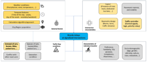
Machine Learning for Bicycle Delay Estimation
Dutch Study Integrates Sparse GPS and Traffic Signal Data to Double Model Fit in Estimating Average Bicycle Delays, Providing Insights for Traffic Management, Cycling Policy, and Infrastructure Development in Urban Environments Addressing Bicycle Delays in Urban Transportation Networks Bicycle use has increased in urban areas as a sustainable alternative to cars for short to medium […]
Machine Learning for Bicycle Delay Estimation Read More »