Data Science

Real-Time Data in Urban Sustainability

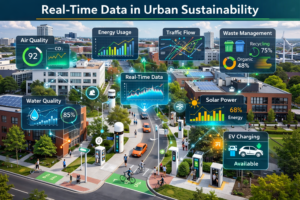
This editorial explores the role of distributed sensors and real-time data in improving urban management, addressing sustainability issues through proactive strategies, digital twins, and inclusive frameworks, drawing on worldwide experiences to inform better decision-making and equitable outcomes. Urban Challenges: The Need for Better Environmental Data Integration Cities are confronting growing pressures from climate change, air […]

Real-Time Data in Urban Sustainability Read More »

Satellite Data Reveals Regional Patterns in India’s Groundwater Depletion

Utilizing GRACE gravity measurements, ERA5 precipitation records, and MODIS land cover classifications, this analysis examines seasonal and regional variations in groundwater storage across India, identifying negative correlations with cropland and urban expansion in northern areas while emphasizing the need for diversified water management to address ongoing depletion. Groundwater Depletion in India: The Problem and Its

Satellite Data Reveals Regional Patterns in India’s Groundwater Depletion Read More »

Why Are Some Watersheds More Sediment-Productive Than Others? An Explainable AI Approach

High-frequency turbidity sensors from 134 USGS stations, paired with RUSLE erosion estimates and explainable random forest models, map sediment yield and delivery ratios across the contiguous United States, revealing that human-modified landscapes dominate sediment transport efficiency while natural factors control total production, and highlighting priority sub-basins for targeted management in the Upper Mississippi and Chesapeake

Why Are Some Watersheds More Sediment-Productive Than Others? An Explainable AI Approach Read More »

Machine Learning for Iceberg Stability: Ground Imagery and Logistic Regression Offer New Practical Insights

Analyzing thousands of icebergs captured in time-lapse footage from Alaska and Greenland, this research demonstrates that logistic regression applied to visible width and height can help estimate the probability of instability providing engineers with a foundational, field-derived method for assessing capsize risk in Arctic coastal environments. The Challenge of Iceberg Capsize in Arctic Waters Iceberg

Machine Learning for Iceberg Stability: Ground Imagery and Logistic Regression Offer New Practical Insights Read More »

Monitoring Amsterdams Bridges with InSAR

A structured Delft–Amsterdam research collaboration integrates bridge typologies, expected failure mechanisms, and satellite viewing geometry to translate one-dimensional MT-InSAR measurements into practical damage indicators, demonstrating how regional-scale millimetre-level displacement data can support systematic structural evaluation of urban bridge networks. The Urban Bridge Monitoring Dilemma Across Europe and beyond, bridge networks are aging under increasing traffic

Monitoring Amsterdams Bridges with InSAR Read More »

Low-Cost SFCW Radar Platform Advances Sub-Daily Environmental Monitoring

Researchers have developed an affordable tower-mounted SFCW radar built around a compact SDR-based VNA and enhanced RF front end. Operating in L- and C-bands with dual polarization, the system captures high-temporal-resolution microwave data on soil, vegetation, and snow processes—directly addressing the temporal gaps that limit satellite observations of rapid Earth system dynamics. The Challenge of

Low-Cost SFCW Radar Platform Advances Sub-Daily Environmental Monitoring Read More »

UAV Airspeed Estimation using Propeller Feedback

Researchers at Delft University of Technology have developed an analytical model that estimates fixed-wing UAV airspeed using only propeller power and rotational speed feedback from standard electronic speed controllers. This computationally efficient, model-free solution provides a practical alternative or redundancy to conventional Pitot tubes, achieving strong accuracy on real flight data.  The Challenge of Reliable

UAV Airspeed Estimation using Propeller Feedback Read More »

Volumetric Disentanglement: A Practical Path to Object-Level Editing in NeRF Scenes

Neural Radiance Fields (NeRFs) have changed how engineers think about 3D capture. With a modest set of photos, you can reconstruct impressively photorealistic 3D scenes. For many teams, that alone feels like magic. But then comes the real-world question: How do you edit those scenes? Remove a chair. Enlarge a TV. Swap out a tree

Volumetric Disentanglement: A Practical Path to Object-Level Editing in NeRF Scenes Read More »

Machine Learning Meets Soil Dynamics

A data-driven review shows how modern machine-learning models consistently outperform traditional empirical equations in predicting soil shear modulus and damping ratio, offering geotechnical engineers a clearer, more efficient path to characterizing dynamic soil behavior while highlighting practical limitations, data requirements, and future research needs. Why Soil Dynamics Still Challenge Engineers Accurate characterization of soil dynamic

Machine Learning Meets Soil Dynamics Read More »

Advancing 3D Land Administration with Point Clouds

Discover how researchers are transforming urban land administration by integrating cadastral floor plans with nationwide airborne LiDAR to create detailed 3D point clouds, offering a cost-effective alternative to BIM for visualizing legal property boundaries in complex vertical structures—paving the way for scalable digital twins. The Challenge of Vertical Urbanization in Land Administration Urban areas are

Advancing 3D Land Administration with Point Clouds Read More »