Multi-temporal sar for oil reservoir monitoring
This study employs multi-temporal SAR interferometry to monitor vertical displacement in the Tengiz oil reservoir.
Multi-temporal sar for oil reservoir monitoring Read More »
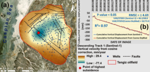
This study employs multi-temporal SAR interferometry to monitor vertical displacement in the Tengiz oil reservoir.
Multi-temporal sar for oil reservoir monitoring Read More »
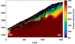
Delving into the Cuolm da Vi slope with advanced 3D seismic tomography unveils critical insights into one of the Alps’ largest active slope instabilities, enhancing geotechnical analysis and hazard assessment in mountainous areas.
Unveiling the Cuolm da Vi Slope: 3D Seismic Tomography Insights Read More »
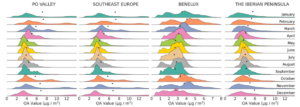
This study integrates chemical transport models with machine learning to create high-resolution maps of organic aerosol concentrations across Europe.
Aerosol Mapping in Europe Read More »
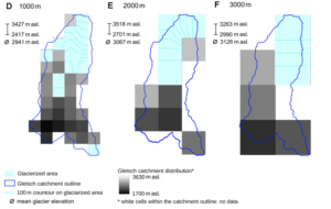
This study examines the effects of meteorological forcing products and model resolutions on glacio-hydrological simulations in a Swiss Alpine catchment, offering practical guidance for achieving reliable runoff and mass balance predictions in data-limited environments facing climate change impacts on water resources. Challenges in Modeling Glacier Runoff and Its Importance Glaciers function as key water reservoirs
Glacier Runoff Models: Influence of Forcing Data and Spatial Resolution Read More »
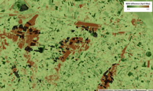
Data-Driven Approach to Quantify Agricultural Losses from Flooding Discover a method that combines Sentinel-2 satellite data, topographic information, and field surveys in a random forest model to classify flood damage in 412 agricultural fields, providing quantitative yield loss estimates for the 2023 Emilia-Romagna event and supporting effective compensation strategies in vulnerable areas. Flood Impacts on
Assessing Crop Flood Damage Using Sentinel-2 Read More »
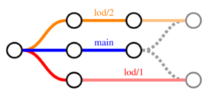
Researchers propose a framework for managing multiple Levels of Detail in 3D city models using CityJSON versioning, with each LoD in a separate branch for independent updates to geometries and semantics, tested on Dutch building data to assess feasibility and maintenance implications. Challenges in Managing Multi-LoD 3D City Models 3D city models are essential in
Versioning for Multi-LoD 3D City Model Management Read More »
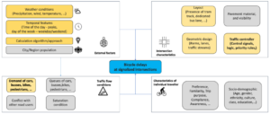
Dutch Study Integrates Sparse GPS and Traffic Signal Data to Double Model Fit in Estimating Average Bicycle Delays, Providing Insights for Traffic Management, Cycling Policy, and Infrastructure Development in Urban Environments Addressing Bicycle Delays in Urban Transportation Networks Bicycle use has increased in urban areas as a sustainable alternative to cars for short to medium
Machine Learning for Bicycle Delay Estimation Read More »
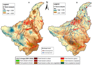
Explore the spatial and temporal shifts in precipitation, evaporation, and streamflow linked to deforestation in the Madeira River basin, the Amazon’s largest sub-basin, through analysis of satellite, reanalysis, and observed data from 1981 to 2016, highlighting significant correlations that inform regional water resource strategies. Deforestation Challenges in the Madeira River Basin The Madeira River basin
Uncovering Links Between Forest Loss and Water Dynamics in the Amazon Read More »
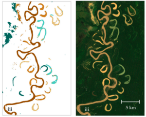
This study employs Google Earth Engine and Landsat 7 imagery alongside random forest classification to analyze multitemporal trends in oxbow lake area, water types, and hydrologic connectivity, providing insights into ecohydrological processes and fish habitat availability in data-scarce tropical river systems such as Bolivia’s Beni River. Challenges in Floodplain Dynamics Monitoring Meandering river floodplains, such
Remote Sensing for Oxbow Lake Monitoring in Turbid Floodplains Read More »
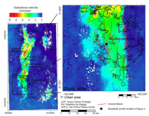
This pioneering research transforms subsidence risk assessment by merging InSAR satellite data with gravimetric mapping, offering a data-driven upgrade to outdated zoning practices and enhancing urban safety in groundwater-dependent regions, around 45 words of cutting-edge engineering insight. Unraveling the Land Subsidence Crisis in Aguascalientes: Why It Demands Urgent Attention In the heart of Mexico’s Aguascalientes
Land Subsidence in Aguascalientes, Mexico: Innovative InSAR and Gravimetric Surveys Read More »