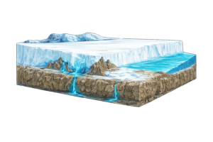
Machine Learning for Iceberg Stability: Ground Imagery and Logistic Regression Offer New Practical Insights
Analyzing thousands of icebergs captured in time-lapse footage from Alaska and Greenland, this research demonstrates that logistic regression applied to visible width and height can help estimate the probability of instability providing engineers with a foundational, field-derived method for assessing capsize risk in Arctic coastal environments. The Challenge of Iceberg Capsize in Arctic Waters Iceberg […]