Computer Science

Glacier Runoff Models: Influence of Forcing Data and Spatial Resolution

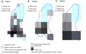
This study examines the effects of meteorological forcing products and model resolutions on glacio-hydrological simulations in a Swiss Alpine catchment, offering practical guidance for achieving reliable runoff and mass balance predictions in data-limited environments facing climate change impacts on water resources. Challenges in Modeling Glacier Runoff and Its Importance Glaciers function as key water reservoirs […]

Glacier Runoff Models: Influence of Forcing Data and Spatial Resolution Read More »

Tradable Mobility Credits for Travel in Europe

A study estimates the effects of Tradable Mobility Credits on Europe’s long-distance leisure travel, where emissions are capped by design and prices emerge from market equilibrium, resulting in a 20% demand reduction, air share dropping from 50% to 42%, and rail increasing from 23% to 32% under a 30% emission target. Emissions Challenge in Long-Distance

Tradable Mobility Credits for Travel in Europe Read More »

Assessing Crop Flood Damage Using Sentinel-2

Data-Driven Approach to Quantify Agricultural Losses from Flooding Discover a method that combines Sentinel-2 satellite data, topographic information, and field surveys in a random forest model to classify flood damage in 412 agricultural fields, providing quantitative yield loss estimates for the 2023 Emilia-Romagna event and supporting effective compensation strategies in vulnerable areas. Flood Impacts on

Assessing Crop Flood Damage Using Sentinel-2 Read More »

Versioning for Multi-LoD 3D City Model Management

Researchers propose a framework for managing multiple Levels of Detail in 3D city models using CityJSON versioning, with each LoD in a separate branch for independent updates to geometries and semantics, tested on Dutch building data to assess feasibility and maintenance implications. Challenges in Managing Multi-LoD 3D City Models 3D city models are essential in

Versioning for Multi-LoD 3D City Model Management Read More »

Machine Learning for Bicycle Delay Estimation

Dutch Study Integrates Sparse GPS and Traffic Signal Data to Double Model Fit in Estimating Average Bicycle Delays, Providing Insights for Traffic Management, Cycling Policy, and Infrastructure Development in Urban Environments Addressing Bicycle Delays in Urban Transportation Networks Bicycle use has increased in urban areas as a sustainable alternative to cars for short to medium

Machine Learning for Bicycle Delay Estimation Read More »

Uncovering Links Between Forest Loss and Water Dynamics in the Amazon

Explore the spatial and temporal shifts in precipitation, evaporation, and streamflow linked to deforestation in the Madeira River basin, the Amazon’s largest sub-basin, through analysis of satellite, reanalysis, and observed data from 1981 to 2016, highlighting significant correlations that inform regional water resource strategies. Deforestation Challenges in the Madeira River Basin The Madeira River basin

Uncovering Links Between Forest Loss and Water Dynamics in the Amazon Read More »

Remote Sensing for Oxbow Lake Monitoring in Turbid Floodplains

This study employs Google Earth Engine and Landsat 7 imagery alongside random forest classification to analyze multitemporal trends in oxbow lake area, water types, and hydrologic connectivity, providing insights into ecohydrological processes and fish habitat availability in data-scarce tropical river systems such as Bolivia’s Beni River. Challenges in Floodplain Dynamics Monitoring Meandering river floodplains, such

Remote Sensing for Oxbow Lake Monitoring in Turbid Floodplains Read More »

Numerical Modeling of Tunnel Behavior Under Fire Exposure

Unveiling Fire Effects on Tunnels: A Detailed Examination of Nonlinear Finite Element Strategies That Simulate Thermo-Mechanical Responses, Validating Models Against Large-Scale Tests to Inform Structural Assessments and Improve Design Practices in Reinforced Concrete Infrastructure – Essential Insights for Engineers. Addressing Tunnel Fire Risks: Significance for Structural Design Tunnel fires, although infrequent, can lead to significant

Numerical Modeling of Tunnel Behavior Under Fire Exposure Read More »

Visual Impact of Blue-Green Infrastructure in Historic Urban Areas

This study develops a framework combining UAV photogrammetry with multi-layered perception methods to examine blue-green infrastructure’s effects on visual attention, preferences, and cognitive interpretations in historic urban areas, offering replicable tools for heritage-sensitive planning and evaluation. Underexplored Visual Role of Blue-Green Infrastructure in Historic Urban Areas Historic urban areas (HUAs) serve as repositories of cultural

Visual Impact of Blue-Green Infrastructure in Historic Urban Areas Read More »

Expected Annual Damage European Coastal Transport Infrastructure Under Global Warming

Probabilistic Assessment Reveals Escalating Damages from Rising Sea Levels This study evaluates coastal flood impacts on European road and rail networks across global warming scenarios, projecting baseline annual damages of €519 million rising potentially to €1,090 million at 4°C, with greater affected lengths for roads but higher costs for rails, signaling needs for targeted adaptation

Expected Annual Damage European Coastal Transport Infrastructure Under Global Warming Read More »