Land Subsidence in Aguascalientes, Mexico: Innovative InSAR and Gravimetric Surveys
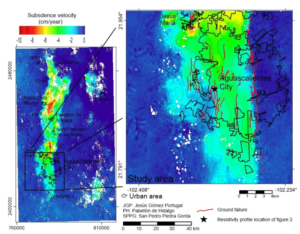
This pioneering research transforms subsidence risk assessment by merging InSAR satellite data with gravimetric mapping, offering a data-driven upgrade to outdated zoning practices and enhancing urban safety in groundwater-dependent regions, around 45 words of cutting-edge engineering insight. Unraveling the Land Subsidence Crisis in Aguascalientes: Why It Demands Urgent Attention In the heart of Mexico’s Aguascalientes […]
Land Subsidence in Aguascalientes, Mexico: Innovative InSAR and Gravimetric Surveys Read More »