This research addresses the disconnect between satellite data and policy-making in West Africa. It introduces advanced Earth observation techniques for soil erosion monitoring and outlines a strategic pathway to integrate these insights into national frameworks, supporting efforts to achieve Land Degradation Neutrality by 2030.
Tackling Soil Erosion in West Africa
Soil erosion in West Africa threatens food systems, water regulation, and ecosystem health. The region faces both water and wind erosion, worsened by high-intensity rainfall and dry Harmattan winds. Human activities such as deforestation and overgrazing further accelerate soil degradation, reducing fertility and ecosystem stability. Despite the severity, monitoring efforts remain fragmented and poorly integrated into policy frameworks, hindering effective intervention and planning. The research underlines the need for timely, spatially explicit evidence to inform policy, especially as African countries aim for Land Degradation Neutrality (LDN) by 2030, as outlined by the United Nations Convention to Combat Desertification (UNCCD) and Sustainable Development Goal (SDG) 15.3.1.
Remote sensing (RS) offers a promising solution by providing consistent, regional observations that support several dimensions of soil security, including condition, capacity, and connectivity. However, the uptake of these technologies in policy-making is limited by barriers such as institutional fragmentation, lack of standard methods, and insufficient technical capacity.
Cutting-Edge Techniques for Monitoring
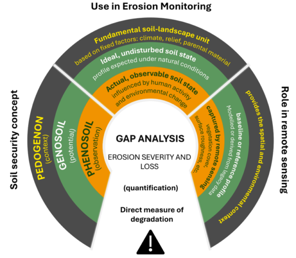
The research synthesizes advanced Earth observation approaches, emphasizing remote sensing’s role in capturing soil erosion dynamics. Optical and radar technologies, including Synthetic Aperture Radar (SAR) time series, interferometry, and aerosol products for dust monitoring, are highlighted as key tools. These technologies offer multiscale data on land surface properties and dynamics, crucial for assessing the phenosoil state—the observable soil profile reflecting land management impacts.
Remote sensing indicators such as the Normalized Difference Vegetation Index (NDVI) and microwave radar sensors are used to estimate vegetation cover and surface roughness, respectively. These indicators, when combined with models like the Universal Soil Loss Equation (USLE), enhance soil loss predictions. Emerging capabilities like hyperspectral sensors and nanosatellite constellations further refine erosion monitoring by detecting changes in mineralogy and capturing erosion events shortly after storms.
To ensure accuracy and relevance, the research stresses the importance of calibration and validation using field data, erosion plots, and community observations. This approach addresses the limitations of indirect measures and enhances the reliability of satellite indicators for local conditions.
Key Findings and Strategic Pathways
The study demonstrates how validated satellite indicators can be aligned with soil security dimensions and embedded into operational pathways that connect scientific evidence to policy-making. By integrating Earth observation data into decision frameworks, the research provides a practical route to identify erosion hotspots, target interventions, and track outcomes.
Key barriers to policy uptake are identified, including limited human and technical capacity, institutional fragmentation, and financing constraints. The research proposes an operational pathway aligned with UNCCD Land Degradation Neutrality and SDG 15.3.1 reporting, emphasizing the roles of national agencies and regional initiatives like WASCAL and SERVIR West Africa.
Future Directions and Opportunities
This research offers a transformative approach to soil erosion monitoring in West Africa, paving the way for improved soil security and sustainable land management. By embedding satellite indicators into routine policy cycles, countries can advance their 2030 LDN commitments and enhance ecosystem resilience.
The study invites further collaboration and input from stakeholders to refine these methodologies and expand their application across the region. Interested parties are encouraged to engage with the findings and contribute to ongoing efforts in soil security.
Reference: Ouattara, B. (2026). From satellite data to soil security: Closing the science – policy gap in soil erosion monitoring in West Africa. Soil Security, 22, 100224. DOI: https://doi.org/10.1016/j.soisec.2026.100224