Researchers have developed an affordable tower-mounted SFCW radar built around a compact SDR-based VNA and enhanced RF front end. Operating in L- and C-bands with dual polarization, the system captures high-temporal-resolution microwave data on soil, vegetation, and snow processes—directly addressing the temporal gaps that limit satellite observations of rapid Earth system dynamics.
The Challenge of Rapid Environmental Change: Why Sub-Daily Observations Matter
Satellite-based active microwave sensors play a central role in monitoring Essential Climate Variables (ECVs) such as soil moisture and vegetation water content. However, platforms like Sentinel-1 typically provide revisits only every 2 to 6 days. This cadence is often insufficient to resolve fast-evolving processes in the soil–plant–atmosphere continuum.
Plants transpire during daylight hours as they exchange carbon dioxide, redistributing moisture across the system on timescales of minutes to hours. Events such as rainfall interception, dew formation, and rain-on-snow alter snow microstructure and stratigraphy rapidly. These dynamics influence ecosystem functioning, water and carbon cycles, and the reliability of climate and hydrological models, yet satellites usually capture at most a single moment during their evolution.
Ground-based radar systems can supply the needed high-frequency sampling. Most existing setups, however, depend on high-end vector network analyzers (VNAs), which are costly, power-intensive, and challenging to deploy at scale in remote locations. This restricts the number of instrumented sites and slows research into sub-daily variability.
The platform presented here provides a practical alternative. It combines affordability, robustness, and remote operability, allowing networks of sensors to function autonomously for extended periods while delivering dense time series that complement satellite data.
Engineering an Accessible Radar Solution: Design and Key Innovations
The researchers selected a stepped-frequency continuous-wave (SFCW) architecture, well-suited to static tower deployments where targets change gradually. Compared with pulsed or FMCW approaches, SFCW offers higher average transmit power, strong dynamic range, and straightforward bandwidth adjustment, supporting the targeted sub-10 cm range resolution for resolving vertical scattering profiles.
The core component is the LibreVNA, a low-cost software-defined radio (SDR) vector network analyzer covering up to 6 GHz with modest power consumption (6–7 W during sweeps). To meet performance needs, the team incorporated a custom RF front end: a power amplifier, low-noise amplifier, and RF switch. This configuration enables VV and VH polarimetric measurements using three linearly polarized horn antennas chosen for narrow beamwidth (<20°), high directivity, and compatibility with L-band and lower C-band frequencies aligned with major satellite missions.
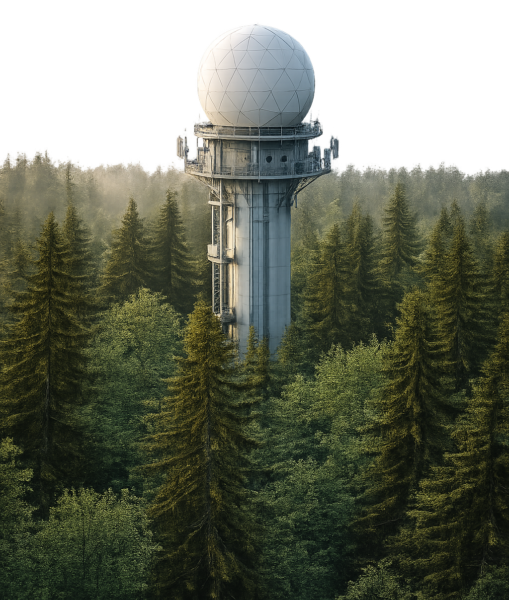
The complete system is housed in a rugged, waterproof flight case mounted on 5 m towers at approximately 40° incidence angle. It includes a Raspberry Pi 5 edge computer, temperature monitoring, SSD storage, and reliable networking (Ethernet primary, with cellular fallback and WiFi mesh between units). Data are streamed to a central InfluxDB server with Grafana visualization, while local storage and retry mechanisms ensure continuity during outages. Remote configuration and management are fully supported.
Calibration employs the far-field full-wave radar equation, using measurements at multiple distances from a perfect electrical conductor (PEC) plate to characterize and remove antenna coupling, internal reflections, and hardware contributions, yielding responses determined solely by the observed medium.
Prototypes were deployed as a C-band system at Weissfluhjoch, Switzerland (focused on snow) and an L-band system at Louvain-la-Neuve, Belgium (focused on vegetation).
Demonstrating Performance: Calibration Results and Field Validation
Tests confirmed the system meets its design goals. With a 2 GHz bandwidth in the C-band, the radar achieved a measured range resolution of 9.17 cm (FWHM), consistent with the theoretical value of 7.5 cm and the requirement of better than 10 cm.
PEC-plate calibration experiments successfully eliminated direct antenna coupling and multiple internal reflections. Processed data aligned closely with theoretical Green’s functions.
Field sensitivity trials at Weissfluhjoch involved placing a metallic shovel at known positions within the radar footprint. Clear backscatter peaks appeared at the expected ranges. Fitting a two-way travel-time model to the peak arrivals produced excellent agreement (R² = 0.9983), validating geometry, range processing, and overall sensitivity.
Over a wheat field, uncalibrated measurements showed strong coupling that obscured the ground return. After calibration, the ground reflection became clearly visible in the anticipated time window, confirming effective removal of system artifacts.
The study concludes that “calibration experiments and preliminary measurements demonstrate that the system achieves stable performance and is capable of capturing high-temporal-resolution microwave signatures relevant for climate monitoring.” The platform fulfills the requirements for dual-band operation, polarimetry, range resolution, long-term autonomy, and cost-effectiveness relative to traditional VNA-based systems.
Path Forward: Broader Impact and Next Steps
This radar platform offers a scalable approach for acquiring dense ground-based microwave observations, supporting improved understanding of sub-daily processes and validation of satellite retrieval methods. It also facilitates expanded sensor networks and advances in radiative transfer modeling.
Ongoing work includes refinement of temperature-dependent calibration and detailed analysis of long time series alongside in-situ measurements.
We thank lead author Jarne Van Mulders and the collaborating team from KU Leuven, Ghent University, UCLouvain, TU Delft, and Boise State University for this valuable engineering contribution to environmental remote sensing. Readers engaged in field instrumentation, radar development, or related climate monitoring are invited to share insights or discuss potential collaboration.
Reference
Van Mulders, J., Vandenbroucke, J., Mareschal, M., Cox, B., Tronquo, E., Marshall, H.-P., Lambot, S., Lievens, H., & De Strycker, L. (2026). Design and Implementation of an SFCW Radar Platform for Environmental Monitoring. NDT, 4(1), 6. https://doi.org/10.3390/ndt4010006