This research refines a GIS-based toolbox by integrating high-resolution land-cover data and new models for afforestation and riparian forest buffers, applied to six European river basins to map suitable locations for large-scale nature-based solutions that reduce hydrometeorological risks and highlight opportunities for combined implementations.
Addressing the Escalating Hydrometeorological Risks with Nature-Based Solutions
Climate change is increasing the frequency and severity of hydrometeorological hazards such as floods, landslides, and droughts. These events have affected over 2.8 billion people worldwide and caused more than 200,000 deaths in the past two decades, with further rises expected. Rapid urban expansion and environmental degradation heighten exposure and losses, making effective adaptation strategies essential.
Traditional grey infrastructure (dams, dikes, and drainage systems) has been the primary response. In recent decades, however, attention has shifted toward nature-based solutions (NBSs). These ecosystem-inspired measures range from small-scale urban features to large-scale catchment interventions such as retention ponds, detention basins, floodplain restoration, and afforestation. Beyond risk reduction, they deliver co-benefits including improved biodiversity, carbon sequestration, and recreational opportunities.
Selecting appropriate NBSs and identifying suitable locations is a critical planning step. Existing geospatial tools are often limited to small-scale or urban contexts, constrained by software compatibility, or reliant on low-resolution data that overlook smaller settlements. An earlier GIS toolbox mapped suitability for four large-scale measures but was built on discontinued ArcMap software and did not include vegetative source-control options.
In rural and peri-urban basins across central and eastern Europe, where agriculture, roads, and ecosystems are regularly threatened by flooding, droughts, erosion, and landslides, accurate planning tools are particularly valuable.
Methodology: Updating the GIS Multi-Criteria Toolbox for Broader Applicability
The study builds directly on the earlier toolbox developed by Mubeen et al. (2021). It was updated for compatibility with ArcGIS Pro 3.3 (and tested in versions 3.4 and 3.5) and expanded with two new models for afforestation (AF) and forest buffer strips (FB). The toolbox was applied to the six RECONECT European collaborator sites: Bregana (Croatia/Slovenia), Jadar and Tamnava (Serbia), Kamchia (Bulgaria), Pilica (Poland), and Vrbanja (Bosnia and Herzegovina).
Hazards were identified from site-specific data and literature, with flooding predominant across all basins. NBS selection drew on a multi-criteria analysis framework informed by preferences from 110 stakeholders across local, regional, and national levels. Top-ranked measures for flood, landslide, and drought hazards were grouped by mechanism: source control (AF, FB), storage (retention/detention; RD), and conveyance (floodplain restoration; FP).
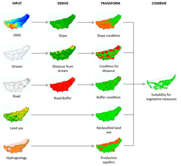
Suitability mapping employed GIS-based multi-criteria analysis. Core criteria included slope, distance from streams and roads, land use/land cover, and hydrogeology (aquifer productivity). Key refinements were the addition of ESA WorldCover 2021 (10 m resolution) alongside Corine Land Cover 2018 to better exclude built-up areas, and hydrogeology data from IHME 1500 for vegetative measures. Conditions were adjusted accordingly: slope ≤60 % for AF and FB; stream distance ≤100 m for FB; road buffers ≥50 m; and productive aquifers for vegetation.
Boolean raster maps were generated at 10 m resolution, intersected to identify areas meeting all criteria, and post-processed to exclude polygons smaller than 1 ha. Validation compared outputs with the previous toolbox using identical Tamnava input data.
Results: Suitability Assessments Across Six River Basins
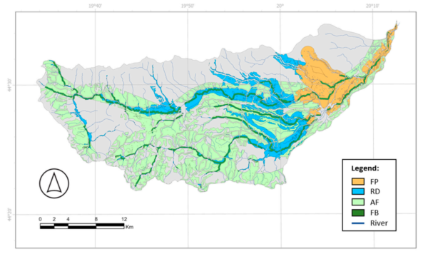
Suitability maps showed that between 7.58 % (Bregana) and 47.07 % (Jadar) of each basin area is suitable for at least one of the four NBSs. Afforestation accounted for the largest suitable area in five of the six basins; retention/detention dominated in Pilica (22.76 % of the basin). Forest buffer strips had the smallest extent, and floodplain restoration was largely restricted to downstream zones.
Source-control measures (AF + FB) covered the greatest combined area in most basins, followed by storage (RD) and conveyance (FP). Slope and aquifer productivity were the primary limiting factors. Overlapping suitable zones, most frequently between afforestation and retention/detention, indicate potential for combined implementations.
Direct comparison with the earlier toolbox on the Tamnava basin showed a 6.93 % reduction in total suitable area (FP decreased 8.92 % from 5,963 ha to 5,431 ha; RD decreased 5.57 % from 8,753 ha to 8,266 ha), attributable to refined land-cover data and updated criteria. Overlay with high-resolution imagery confirmed improved exclusion of small settlements.
Implications for Engineering Practice and NBS Implementation
The refined toolbox provides engineers with a practical, openly documented method for preliminary spatial allocation of large-scale NBSs using globally available datasets. It supports integration with hydrological modelling, stakeholder engagement, and spatial planning while highlighting areas where multiple measures can be combined for enhanced risk reduction.
Reference: Mubeen, A.; Devanand, V.B.; Ruangpan, L.; Vojinovic, Z.; Sanchez Torres, A.; Plavšić, J.; et al. A Geospatial Assessment Toolbox for Spatial Allocation of Large-Scale Nature-Based Solutions for Hydrometeorological Risk Reduction. Hydrology 2025, 12, 272. https://doi.org/10.3390/hydrology12100272