Researchers propose a framework for managing multiple Levels of Detail in 3D city models using CityJSON versioning, with each LoD in a separate branch for independent updates to geometries and semantics, tested on Dutch building data to assess feasibility and maintenance implications.
Challenges in Managing Multi-LoD 3D City Models
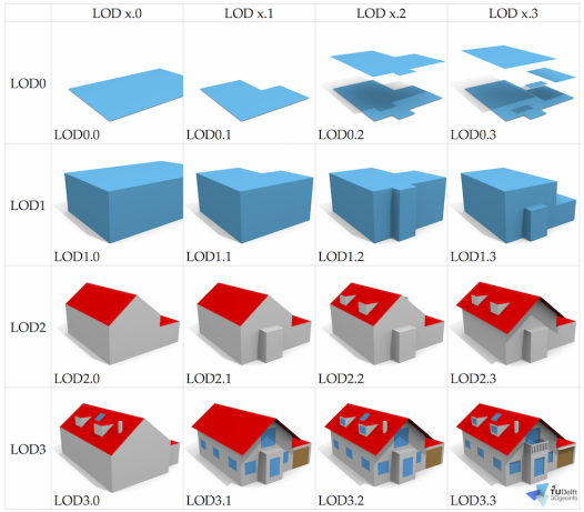
3D city models are essential in applications such as solar energy assessments and wind flow simulations for urban development. These models represent city features in three dimensions, but varying geometric precision is required across uses. The Level of Detail (LoD) concept, defined in formats like CityGML and CityJSON, addresses this with LoDs ranging from basic footprints (LoD0) to detailed interiors (LoD4).
Multi-LoD datasets, which include multiple LoDs for the same features, are scarce due to management difficulties. The research indicates that inconsistencies from different data collection, modeling, and storage methods lead to errors and complicate updates. Higher LoDs can introduce validation issues and may not always enhance analysis accuracy. For engineers, this results in inefficiencies when handling files where only one LoD is needed, or maintaining data integrity during modifications.
This is significant in civil engineering and geospatial analysis. Improved multi-LoD management could support collaboration, change tracking, and scenario testing for urban planning. The study examines the 3D BAG dataset, a nationwide 3D building model for the Netherlands based on building registries and LiDAR data. It features LoDs 0, 1.2, 1.3, and 2.2, with buildings often divided into parts, highlighting practical complexities in dataset handling.
Proposed Framework and Testing Methodology
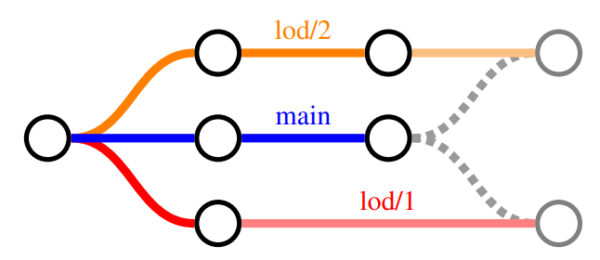
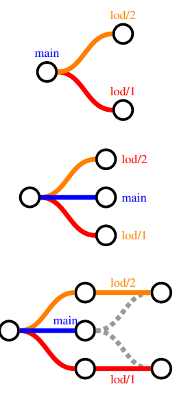
The framework applies versioning to CityJSON files, treating a “repo” as a container for 3D city models inspired by Git’s structure. The approach uses branches to separate LoDs: a “main” branch handles semantics and attributes without geometries, while branches like “lod/1.2” manage each LoD’s geometry. This allows geometric changes to evolve independently from attribute updates.
Initialization begins with a geometry-free CityJSON file committed to “main.” LoD branches are then created by committing filtered files, each with one LoD’s geometry matching the object hierarchy. Tools like “cjio” aid in filtering.
For updates, attribute changes involve checking out “main,” editing, and committing, followed by merging into LoD branches. Geometric modifications occur directly in the relevant LoD branch. Conflicts are avoided by identifying changes at the property level, with “geometry” exclusive to LoD branches.
New objects are added by creating a full file, filtering geometries, and committing to branches. Single-LoD extraction uses branch checkout after syncing with “main.” Multi-LoD outputs require creating a temporary branch and merging incrementally.
The framework was prototyped in “cjv” software, with enhancements for property-level diffing and merging. Testing used a 3D BAG tile, validating operations like commits, merges, and visualizations in tools like “ninja.”
Key Findings and Conclusions
Tests on the 3D BAG tile validated the framework’s feasibility. Initialization separated LoDs effectively, with “main” for attributes and LoD branches for geometries. Attribute updates in “main” merged without conflicts, as shown in history logs and diffs. Geometric changes, such as vertex adjustments in LoD2.2, integrated with semantic updates.
Single-LoD extractions were achieved via branch checkouts, and multi-LoD files (e.g., LoD0 and LoD2.2) were generated accurately after merges, confirmed in viewers. The method managed 3D BAG’s structure, where building parts lack attributes in “main.”
The methodology enables LoD-specific lineage tracking and selective extractions. As stated in the research, “The proposed methodology provides a solution for separating LoDs from each other, so eventually every LoD tracks its own lineage.” However, it adds workflow complexity, requiring structured updates and intermediate files. Updating semantics without geometries challenges the integrated nature of 3D models, making this an exploratory demonstration rather than a fully mature tool.
Future Implications and Opportunities
The research suggests potential for interfaces that automate branching, improving accessibility for engineers in urban applications. It also highlights needs for refined object identity in versioning, particularly for geometries, and notes LoDs’ links to semantics.
Reference: Vitalis, S., Arroyo Ohori, K., & Stoter, J. (2022). Applying versioning to multi-LoD 3D city models. International Archives of the Photogrammetry, Remote Sensing and Spatial Information Sciences, 48(4/W4-2022), 177-182. https://doi.org/10.5194/isprs-archives-XLVIII-4-W4-2022-177-2022.