Explore how sequential classifiers enhance urban land use change modeling, achieving high accuracy and thematic depth. This research on Switzerland’s Swiss Plateau predicts urban dynamics with precision, aiding urban planning and policy decisions.
Why Current Urban Models Fall Short
Urban land use change models are essential for predicting spatial development and its socio-economic and environmental impacts. However, many existing models treat urban areas as uniform, ignoring variations in residential and economic intensity. This simplification limits their ability to integrate critical information on mobility patterns, biodiversity, urban form, and microclimate, where differentiation between urban use types and their intensities is crucial. As urban expansion and densification continue globally, the demand for models that can accurately capture these dynamics becomes increasingly urgent.
The current landscape of land use/land cover change (LULCC) models often lacks thematic depth and regional scope, particularly in urban contexts. Most models are calibrated for single cities, failing to account for the complex dynamics across multiple settlements. This oversight is significant because urban decay and renewal can occur simultaneously in different areas, influenced by the interactions between proximate settlements. The absence of high-resolution models that can capture these internal transformations results in the exclusion or generalization of smaller settlements and hamlets, which are crucial to understanding broader urban dynamics.
In Switzerland, this gap is particularly pronounced. The Swiss Plateau, a region experiencing significant population growth, requires a nuanced understanding of urban dynamics to guide future planning effectively. Existing models often include only a single urban land-use category or fail to differentiate between economic sectors and densities. This limitation hinders the ability to anticipate and plan for the diverse developmental challenges faced by the region’s various municipal typologies.
Introducing a Two-Stage Classifier Model
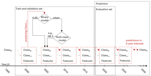
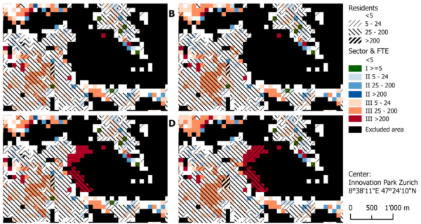
Addressing these limitations, the research introduces a high-resolution urban LULCC model specifically designed for the Swiss Plateau. This model employs a two-stage approach using sequential XGBoost classifiers. The first classifier predicts whether a cell will become urban, while the second assigns one of 27 urban land use classes based on residential density, job density, and economic sector. This design explicitly separates the processes of urban expansion and internal transformation, allowing for more accurate predictions by focusing on sector- and density-specific changes within urban areas.
The model’s development involved training on five-year intervals from 1995 to 2015, with validation using 2020 data. This approach ensures that the model can capture long-term trends and dynamics, providing reliable projections up to 2050. The use of XGBoost efficiently captures complex, non-linear interactions and generalizes well to unseen data, enhancing predictive capabilities across diverse settlement contexts.
By incorporating both residential population and economic sector densities, the model offers a rich thematic depth previously unavailable in regional LULCC models. This allows for a differentiated understanding of urban dynamics across local and regional contexts, enabling planners to test how specific urban land use classes affect development in their proximate surroundings and neighboring settlements.
Impressive Accuracy and Insights
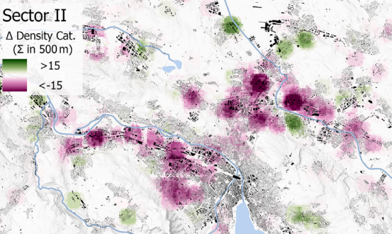
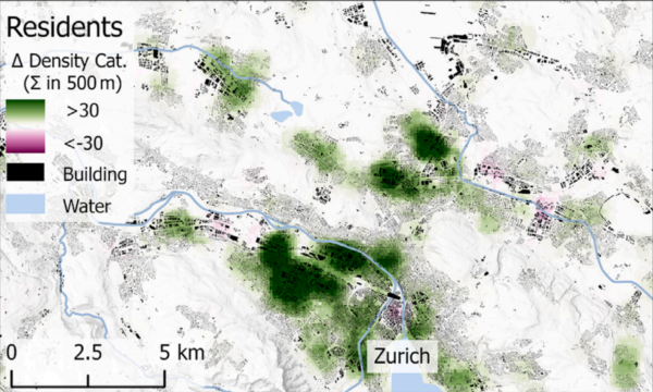
The model demonstrated impressive performance, achieving a 92.3% accuracy for urban extent predictions and a fuzzy kappa of 0.692 for class predictions. These results underscore the model’s ability to accurately capture urban land use transitions, offering a more nuanced evaluation of LULCC model performance than traditional metrics. The study’s projections to 2050 reveal significant sector- and density-specific development patterns, with core cities expected to densify the most, gaining an additional 300 hectares of high-density urban area. Meanwhile, peri-urban and residential municipalities are projected to expand primarily at low to medium intensities, increasing their area by 3.7%.
These findings highlight the model’s capacity to anticipate diverse urban dynamics and support informed planning across various futures. By illustrating how strategic projects can reshape land use beyond intervention sites, the research provides valuable insights for urban planners and policymakers aiming to guide development in desired directions.
Shaping the Future of Urban Planning
The introduction of this high-resolution, thematically rich urban LULCC model marks a significant advancement in the field of urban planning. By providing a detailed understanding of future urban dynamics, the model equips planners with the tools needed to prepare for, support, or adjust policies to guide development effectively. The research paves the way for further exploration of regional variations and the impact of local developments on neighboring settlements, offering a robust framework for future studies.
We extend our gratitude to the authors for their invaluable contribution to urban land use modeling. We invite urban planners, researchers, and policymakers to engage with this work, share their insights, and explore the model’s potential applications in diverse contexts.
Reference: Räth, Yves M., Grêt-Regamey, Adrienne, van Strien, Maarten J. High-resolution urban land use change modeling via sequential classifiers. Computers, Environment and Urban Systems 125, 2026. DOI: https://doi.org/10.3929/ethz-c-000792868