Exploring the integration of GNSS-derived tropospheric gradients with zenith total delays in weather forecasting models, this study examines both sparse and dense station networks. It highlights improvements in humidity field accuracy and forecast quality, especially in regions with limited GNSS stations.
Bridging Gaps in Weather Forecasting
In meteorology, accurate weather forecasts are essential for planning and safety. Global Navigation Satellite Systems (GNSS) have become crucial tools, offering the ability to monitor atmospheric conditions. Traditionally, GNSS-derived zenith total delays (ZTDs) have enhanced forecasts by providing data on atmospheric water vapor. However, ZTDs mainly offer vertical atmospheric information, leaving a gap in horizontal data that could further refine predictions.
This is where tropospheric gradients (TGs) become relevant. TGs, also derived from GNSS data, provide insights into the horizontal distribution of atmospheric moisture, offering a more comprehensive atmospheric view. Despite their potential, TGs have not been widely integrated into operational weather forecasting models due to assimilation complexity and limited validation studies.
The research by Thundathil et al. addresses this gap by investigating the assimilation of both ZTDs and TGs into numerical weather models. The study explores how these variables can improve forecast accuracy, particularly in regions with sparse GNSS station networks. This advancement is significant, as many areas lack the dense GNSS networks prevalent in Europe, limiting the effectiveness of ZTD-only assimilation.
Refined Techniques in Weather Modeling
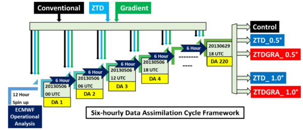
The researchers employed a newly developed forward operator for TGs, integrating it into the Weather Research and Forecasting (WRF) model. This operator efficiently calculates the north and east gradient components of the troposphere, crucial for understanding horizontal moisture distribution. The study utilized both dense (0.5° resolution) and sparse (1° resolution) GNSS station networks to assess the impact of TG assimilation on weather forecasts.
The methodology involved a series of data assimilation experiments using the WRF model version 4.4.1, widely used for both research and operational forecasting. The experiments were conducted over a two-month period, focusing on the European region. Data for these experiments were sourced from the GFZ Helmholtz Centre for Geosciences, ensuring a robust dataset for analysis.
By comparing the assimilation of ZTDs alone versus the combination of ZTDs and TGs, the researchers aimed to quantify the improvements in forecast accuracy. The study’s innovative approach lies in its focus on the potential of TGs to complement existing ZTD data, particularly in areas with limited GNSS infrastructure.
Promising Outcomes and Insights
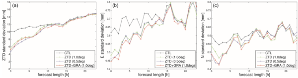
The study’s results are promising. The assimilation of TGs alongside ZTDs from sparse station networks significantly enhanced the accuracy of humidity fields in weather models. Remarkably, improvements with sparse networks were comparable to those obtained by assimilating only ZTDs from dense networks. This suggests that TGs can effectively supplement ZTD data, providing a cost-effective means to improve forecasts in regions with fewer GNSS stations.
The study concludes that incorporating TGs into operational weather forecasting models can lead to substantial improvements in forecast quality. This is particularly relevant for predicting heavy precipitation and severe weather events, critical challenges in meteorology. The findings encourage weather forecasting agencies to consider TG assimilation, especially in regions where expanding GNSS networks may not be feasible.
Future Directions and Opportunities
This research opens new avenues for enhancing weather forecasting accuracy through the integration of GNSS-derived data. By demonstrating the value of TGs in complementing ZTDs, the study provides a pathway for more comprehensive atmospheric modeling. The implications are particularly significant for regions with limited GNSS infrastructure, where cost-effective solutions are essential.
Looking ahead, further research could explore the application of TG assimilation in different climatic regions and weather models. The potential for real-time implementation of these findings could revolutionize weather forecasting, making it more accurate and reliable worldwide.
Reference: Rohith Thundathil, Florian Zus, Galina Dick, and Jens Wickert. Assimilation of global navigation satellite system (GNSS) zenith delays and tropospheric gradients: a sensitivity study utilizing sparse and dense station networks. DOI: https://doi.org/10.5194/amt-18-4907-2025