This study employs multi-temporal SAR interferometry to monitor vertical displacement in the Tengiz oil reservoir. Utilizing Sentinel-1 and COSMO-SkyMed satellite missions, researchers identified subsidence hotspots, providing a new approach to understanding and managing ground deformation in oil fields.
Why Monitoring Matters
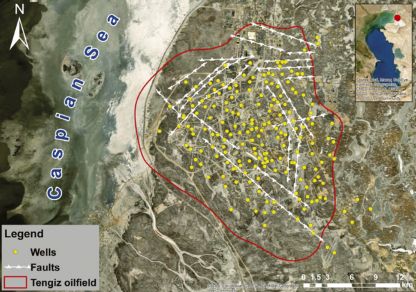
The Tengiz oil field, situated on the Caspian Sea coast, is among the largest globally and has historically faced continuous subsidence due to oil extraction. This ground deformation challenges the petroleum industry by potentially affecting infrastructure stability and operational safety. Traditional in-situ geodetic measurements offer limited coverage and are often impractical for extensive areas like Tengiz. This study addresses the need for a comprehensive and efficient method to monitor vertical displacements over large oil fields using advanced remote sensing techniques.
Advanced Techniques in Action
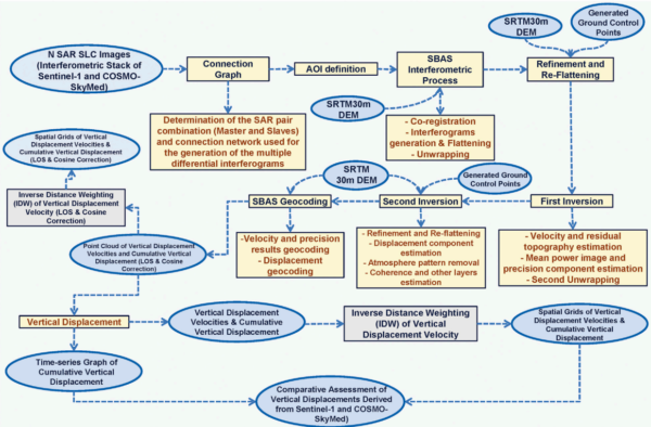
The research utilizes Sentinel-1 and COSMO-SkyMed satellite missions to assess vertical displacement velocities at the Tengiz oil field from 2018 to 2020. The study employs the Small Baseline Subset (SBAS) time-series technique for interferometric processing of radar images, enabling the detection of subsidence hotspots and analysis of vertical displacement velocities and cumulative vertical displacement.
Sentinel-1 provides medium-resolution C-band radar images, while COSMO-SkyMed offers high-resolution X-band images. By using these complementary datasets, the study enhances the precision and density of displacement measurements. Geospatial and statistical analyses were conducted to determine the spatial relationships between displacement patterns, wells, and faults in the study area.
Notable Findings
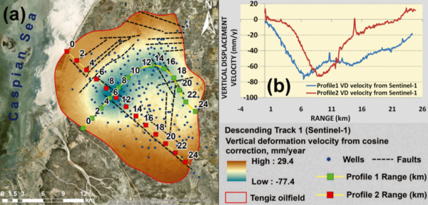
The study found that the Tengiz oil field experienced continuous subsidence during 2018-2020, with maximum annual vertical displacement velocities of -77.4 mm/y and -71.5 mm/y as measured by Sentinel-1 and COSMO-SkyMed, respectively. The vertical displacement velocities derived from both satellite missions showed a strong statistical relationship, with R² values of 0.73 or higher and RMSE values of 3.68 mm or less.
The cumulative vertical displacement for the most subsiding location demonstrated a high correlation between the two datasets, with an R² value of 0.97 and an RMSE of ±4.69. These results highlight the reliability of using multi-satellite SAR imagery for monitoring vertical displacements in large oil fields.
Future Directions and Industry Impact
This research provides valuable insights into the ongoing ground deformation processes at the Tengiz oil field, offering a reliable method for continuous monitoring of subsidence. The findings have significant implications for the petroleum industry, informing strategies to mitigate risks associated with ground deformation. The study sets a precedent for future research on multi-satellite monitoring of vertical displacements in other oil and gas fields worldwide.
The authors have significantly contributed to the field of remote sensing and geospatial analysis. Their work opens new possibilities for the application of SAR interferometry in managing oil reservoirs. Researchers and industry professionals are encouraged to explore these findings further and consider their potential applications in other contexts.
Reference: Bayramov E, Buchroithner M, Kada M, Duisenbiyev A, and Zhuniskenov Y (2022) Multi-Temporal SAR Interferometry for Vertical Displacement Monitoring from Space of Tengiz Oil Reservoir Using SENTINEL-1 and COSMO-SKYMED Satellite Missions. Front. Environ. Sci. 10:783351. DOI: https://doi.org/10.3389/fenvs.2022.783351