Researchers have developed a high-resolution spatio-temporal population model for German cities, offering new insights into urban population dynamics. This model addresses the limitations of static census data, providing crucial information for urban planning, infrastructure, and disaster management by capturing daily population movements.
Understanding Urban Dynamics
Urban population distribution is a dynamic phenomenon, yet traditional population maps offer only static snapshots, typically reflecting nighttime residential patterns. This static nature fails to capture the daily ebb and flow of people across city spaces, leading to potential misestimations in urban planning and infrastructure services. As cities continue to grow, with projections suggesting that 68% of the global population will reside in urban areas by 2050, understanding the spatial distribution of people throughout the day becomes increasingly critical. This knowledge is vital for various domains, including traffic management, critical infrastructure development, and disaster management. Static population data does not account for the high mobility of urban populations, where people move from residential areas to business districts, educational institutions, and commercial centers during the day. Consequently, analyses based on static data can lead to inaccurate conclusions, affecting decision-making processes in urban planning and emergency response strategies.
Innovative Modeling Approach
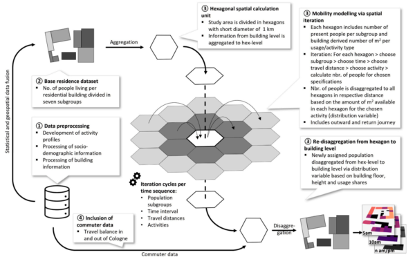
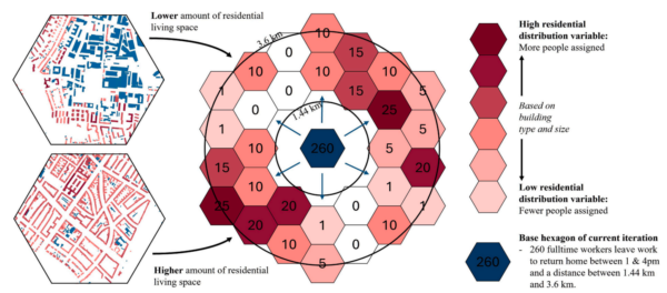
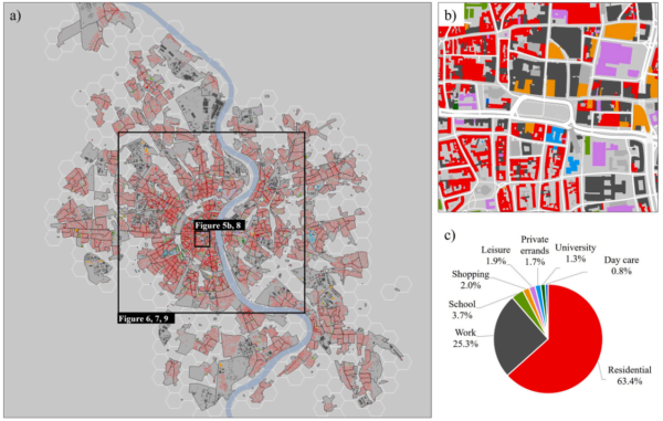
The researchers have developed a spatio-temporal population model specifically for German cities, leveraging the abundant public data available in the country. This model is designed to estimate the number of people present in individual buildings at seven different time intervals throughout the day. The city of Cologne was used as a case study, with successful application of the model also demonstrated in Hamburg. The model employs a dasymetric mapping approach, which combines extensive socio-demographic population and building data with mobility information. Unlike real-world positioning data, which relies on direct measurements from sources like mobile phones and GPS, the dasymetric approach uses geodata, census statistics, and mobility information to indirectly model population mobility. This method is advantageous in Germany, where detailed census data and geodata are publicly available, allowing for a cost-free and transferable model across various cities. The model’s high spatial and temporal resolution provides city-wide population maps for seven time sequences, detailing the total population and specific subgroups, such as children and retirees, at the building level.
Significant Findings
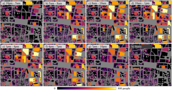
The results of this model demonstrate significant improvements over traditional static census data. The spatio-temporal population maps reveal strong time-dependent differences in population distribution, highlighting discrepancies of up to six times more people in Cologne’s inner city at midday compared to static data. These findings underscore the importance of incorporating time-dependent data into population-based analyses. The model’s accuracy was validated against three independent datasets: ENACT-POP, emergency call locations, and mobile phone location data, all of which showed good correlation metrics. The study successfully illustrates the dynamic nature of urban populations and the necessity for models that reflect these changes to support informed decision-making in urban planning and emergency management.
Future Directions
This research opens new avenues for enhancing urban planning, traffic modeling, and disaster management by providing a dynamic view of population distribution. The model’s reliance on publicly accessible data ensures its applicability across various German cities, offering a scalable solution for urban population modeling. Future research could explore the integration of additional data sources or expand the model’s application to other countries with similar data availability. The authors’ contribution is invaluable for those in urban planning and related fields, and they welcome further engagement from researchers and practitioners interested in advancing this area of study.
Reference: Peter Priesmeier, Alexander Fekete, Michael Haberl, Christian Geiß, Roland Baumhauer, Hannes Taubenböck. “Modelling spatio-temporal distribution of urban population – A high-resolution model for German cities.” DOI: https://doi.org/10.1016/j.compenvurbsys.2026.102419