Geomatics

Annual Memory in the Terrestrial Water Cycle 

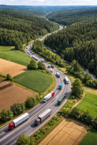
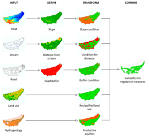
This research refines a GIS-based toolbox by integrating high-resolution land-cover data and new models for afforestation and riparian forest buffers, applied to six European river basins to map suitable locations for large-scale nature-based solutions that reduce hydrometeorological risks and highlight opportunities for combined implementations. Addressing the Escalating Hydrometeorological Risks with Nature-Based Solutions Climate change is […]

Annual Memory in the Terrestrial Water Cycle  Read More »

3d historical city

Reconstructing Historical 3D City Models from Maps

Researchers at TU Delft present a methodology to generate plausible 3D city models from scanned historical maps, using alignment, procedural modeling, and height inference to minimize manual work and support applications like population estimation, disease mapping, and spatial simulations for European cities between 1700 and 2000. Challenges in Historical 3D City Modeling and Their Significance

Reconstructing Historical 3D City Models from Maps Read More »

transport optimisation with data driven simulation

Optimizing Transportation Through Cross-Sector Data-Driven Simulation

Explore an integrated framework that combines data-driven modeling with simulation technologies to facilitate collaboration between small agriculture and forestry businesses, improving resource utilization and addressing seasonal demand variations in transportation management, offering practical insights for enhanced efficiency in developing EU economies like Latvia. Addressing Seasonal Challenges in Agricultural and Forestry Transportation Small enterprises in agriculture

Optimizing Transportation Through Cross-Sector Data-Driven Simulation Read More »

Insar for landslide detection with a bridge

Analyzing Landslide-Bridge Interactions Through InSAR and Numerical Modeling

This study integrates InSAR satellite monitoring with three-dimensional numerical modeling to examine the effects of a landslide on a bridge, addressing the one-dimensional limitations of InSAR through modeling-derived displacement directions and validating simulations with observed surface deformations for improved understanding of infrastructure vulnerabilities in geologically unstable regions. Understanding the Challenge: Landslides and Infrastructure Risks Landslides

Analyzing Landslide-Bridge Interactions Through InSAR and Numerical Modeling Read More »

CittyGML CityJSON tiling

Elevating 3D City Models: Scalable Web Rendering

This innovative research unveils a web-based tool harnessing OGC 3D Tiles 1.1 and WebGPU to streamline the conversion, streaming, and interactive rendering of vast urban digital twins, outpacing older standards with smarter, attribute-aware tiling that boosts efficiency and user engagement. The Challenge of Visualizing Large-Scale Urban Digital Twins and Why It Matters In the realm

Elevating 3D City Models: Scalable Web Rendering Read More »

Satellite Data Reveals Regional Patterns in India’s Groundwater Depletion

Utilizing GRACE gravity measurements, ERA5 precipitation records, and MODIS land cover classifications, this analysis examines seasonal and regional variations in groundwater storage across India, identifying negative correlations with cropland and urban expansion in northern areas while emphasizing the need for diversified water management to address ongoing depletion. Groundwater Depletion in India: The Problem and Its

Satellite Data Reveals Regional Patterns in India’s Groundwater Depletion Read More »

Optimised RANSAC for UAV-Derived Point Clouds

Enhancing Photogrammetric Accuracy: ELISAC Improves Inlier Detection by Up to 57%, Reduces Computation Times, and Yields More Detailed DSMs from UAV Imagery in Forested Environments, Overcoming Spectral and Textural Similarities That Challenge Conventional Algorithms, Essential for Precise 3D Modeling Applications. Outlier Challenges in UAV Image Matching: Issues and Significance Matching corresponding points across overlapping images

Optimised RANSAC for UAV-Derived Point Clouds Read More »

Quay Amsterdam canal construction INSAR SHM

Structural Health Monitoring throught enhanced MT-InSAR

This research introduces a structural-based inverse approach that integrates MT-InSAR characteristics with numerical simulations of damage mechanisms, enabling the identification of the minimum number and optimal placement of persistent scatterers to assess surface displacements’ representativeness for specific infrastructure monitoring needs, surpassing traditional density-based evaluations in precision and reliability. The Challenge in Infrastructure Monitoring A significant

Structural Health Monitoring throught enhanced MT-InSAR Read More »

The Comprehensive Global Building Dataset: GlobalBuildingAtlas

GlobalBuildingAtlas introduces an open dataset with global coverage of 2.75 billion building polygons, 3 m resolution height maps, and LoD1 3D models, derived from satellite imagery, offering enhanced detail for urban analysis, planning, and monitoring progress toward the UN’s Sustainable Development Goals. The Need for Detailed Global Building Information Buildings serve as the foundation of

The Comprehensive Global Building Dataset: GlobalBuildingAtlas Read More »

Why Are Some Watersheds More Sediment-Productive Than Others? An Explainable AI Approach

High-frequency turbidity sensors from 134 USGS stations, paired with RUSLE erosion estimates and explainable random forest models, map sediment yield and delivery ratios across the contiguous United States, revealing that human-modified landscapes dominate sediment transport efficiency while natural factors control total production, and highlighting priority sub-basins for targeted management in the Upper Mississippi and Chesapeake

Why Are Some Watersheds More Sediment-Productive Than Others? An Explainable AI Approach Read More »