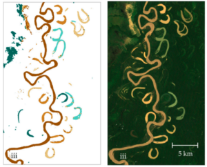
Remote Sensing for Oxbow Lake Monitoring in Turbid Floodplains
This study employs Google Earth Engine and Landsat 7 imagery alongside random forest classification to analyze multitemporal trends in oxbow lake area, water types, and hydrologic connectivity, providing insights into ecohydrological processes and fish habitat availability in data-scarce tropical river systems such as Bolivia’s Beni River. Challenges in Floodplain Dynamics Monitoring Meandering river floodplains, such […]
Remote Sensing for Oxbow Lake Monitoring in Turbid Floodplains Read More »