This study integrates InSAR satellite monitoring with three-dimensional numerical modeling to examine the effects of a landslide on a bridge, addressing the one-dimensional limitations of InSAR through modeling-derived displacement directions and validating simulations with observed surface deformations for improved understanding of infrastructure vulnerabilities in geologically unstable regions.
Understanding the Challenge: Landslides and Infrastructure Risks
Landslides present a significant global hazard, with potential to cause substantial damage to infrastructure such as bridges and viaducts. These phenomena can lead to structural displacements, rotations, or collapse, influenced by factors including volume, kinematics, material composition, and orientation. Interactions may occur longitudinally or transversely, with partial or full involvement, complicating correlations between landslide types and resulting damage.
Existing studies on bridge-landslide interactions lack models that fully simulate structural responses across various scenarios. Conventional monitoring methods, like inclinometers and piezometers, deliver localized data but face challenges in accessibility, cost, and durability under deformation. Synthetic Aperture Radar Interferometry (InSAR) enables broad-scale, cost-effective tracking of surface deformations, particularly for slow-moving landslides. However, InSAR’s measurements are confined to the Line of Sight (LOS), potentially underestimating three-dimensional movements, especially horizontal components typical in landslides.
This issue is pronounced in regions like Italy’s northern Apennines, marked by geological instability. Converting LOS data to accurate 3D components involves assumptions that may introduce errors, and InSAR cannot assess subsurface dynamics or predict evolutions. Numerical modeling complements this by simulating internal behaviors, but requires observational data for validation. Combining InSAR with modeling supports deformation forecasting and risk management, aiding engineers in maintaining transport infrastructure integrity.
Research Approach and Key Methods
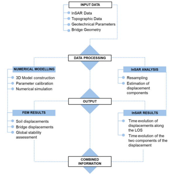
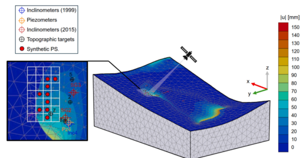
The study employs an integrated method combining InSAR satellite monitoring with 3D numerical modeling to assess landslide impacts on bridges. InSAR supplies surface deformation data over large areas, while modeling provides 3D simulations and movement direction insights. Numerical analysis used Plaxis 3D software to develop a site model. Topography was based on 2021 contour lines at 5 m intervals. The soil was modeled as uniform silty-clay, per grain size analyses. The landslide dimensions included 1000 m length, 300 m average width, 10° incline, and up to 80 m sliding surface depth. Volumes were divided into stable soil and landslide, with shared properties except strength parameters refined via back-analysis. A sliding interface used residual strength values calibrated from literature and site data.
The Hardening Soil model captured nonlinear soil behavior, including strain-dependent stiffness. The bridge was represented with three spans: two 32.9 m spans using post-tensioned beams and one 8.95 m slab, supported by reinforced concrete piers and abutments on 6-7 m diameter caissons to 12 m depth.
InSAR utilized Persistent Scatterer technique on ascending and descending orbits. LOS displacements were converted to 2D components via 25 m grid resampling, selected after evaluating alternatives for data homogeneity amid vegetation effects. Temporal alignment employed linear interpolation. Projections aligned with the landslide’s main direction from modeling, assuming negligible longitudinal movements, to derive transverse and vertical components. The method was applied to a roto-translational landslide in Parma, Italy, affecting a motorway bridge amid Scabiazza Sandstones over Blocky Clays with Palombini Shales. Historical data from inclinometers (4-6 mm/month at 37-80 m), piezometers (near-surface groundwater), and targets (average 6.5 cm/year) supported model calibration. This workflow involved parallel modeling and InSAR processing, followed by integration where modeling informed InSAR decomposition and satellite data validated simulations.
Results and Conclusions
Numerical simulations indicated non-uniform displacements in the landslide, with maxima of 14 cm downstream, 10 cm upstream, and 4 cm near the bridge, reflecting the structure’s stabilizing role. Horizontal components predominated (up to -3 cm in one axis, 2.5 cm in another), with minimal vertical shifts, aligning with sliding kinematics. Bridge elements in the landslide zone (Pier 2, Abutment 2) showed base displacements in the landslide direction, leading to downstream tilting from lateral thrust. The global safety factor was 1.2274, near the stability threshold.
InSAR results, after 25 m resampling, showed opposing LOS signs (positive ascending, negative descending), confirming westward horizontal movement. Over 2018-2022, transverse displacements reached ~40 mm, vertical ~ -20 mm, indicating dominant lateral motion with subsidence. Field data comparison revealed decelerating velocities: 4 cm/year (1975-1999), 2 cm/year (2004-2015), 1 cm/year (2018-2022). Upstream alignments were consistent, with modeling addressing downstream data gaps by indicating higher displacements. The study concludes that integration yields complementary information, as “the integration of InSAR and numerical modelling provided complementary and more detailed information compared to the isolated use of each approach.” It clarifies landslide kinematics and infrastructure effects, with applicability to similar scenarios for risk evaluation.
Implications and Future Potential
This method supports enhanced geohazard assessment, potentially aiding infrastructure monitoring and mitigation strategies. We thank Erica Cernuto, Diana Salciarini, Filippo Ubertini, and Giorgia Giardina for their contribution. Readers with relevant input are invited to connect via the paper’s contacts.
For further reading, see: Cernuto, E., Salciarini, D., Ubertini, F., & Giardina, G. (2025). Landslide-Bridge Interaction: A combined approach based on InSAR data and numerical modelling. International Journal of Disaster Risk Reduction, 126, 105568. https://doi.org/10.1016/j.ijdrr.2025.105568.