This study examines the effects of meteorological forcing products and model resolutions on glacio-hydrological simulations in a Swiss Alpine catchment, offering practical guidance for achieving reliable runoff and mass balance predictions in data-limited environments facing climate change impacts on water resources.
Challenges in Modeling Glacier Runoff and Its Importance
Glaciers function as key water reservoirs in mountainous regions, releasing meltwater that supports rivers, ecosystems, and human activities during low-precipitation periods. In areas such as the Swiss Alps or the Himalayas, glacier contributions are particularly significant for late-summer streamflow, underscoring the need for precise runoff forecasts in water management, hydropower, agriculture, and risk assessment. With ongoing glacier retreat due to climate change, glacio-hydrological modeling is essential to address data gaps and simulate processes in remote areas.
However, these models encounter challenges including limited high-elevation observations, uncertainties in temperature and precipitation inputs, and trade-offs in spatial resolution. In data-scarce settings, gridded climate products often introduce biases from unresolved topographic effects, especially in precipitation estimates. Model resolution also plays a role, as coarser grids may overlook glacier elevation distributions, slopes, and fine-scale features, potentially affecting simulations of small glaciers and runoff timing.
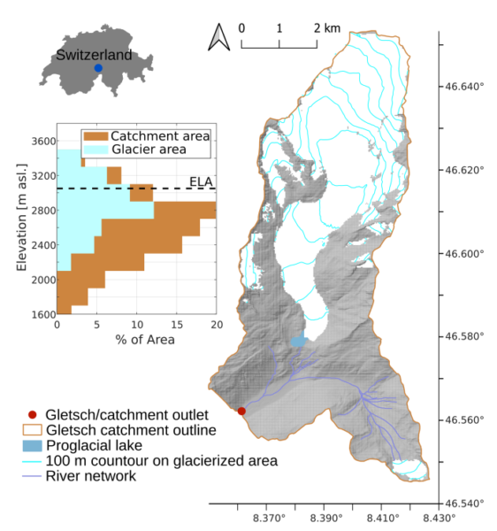
Such inaccuracies can impact infrastructure decisions and flood risk evaluations. Using the well-monitored Gletsch catchment in Switzerland (39.4 km², 44% glacierized) as a case study allows for testing these factors, with implications for broader applications. The research emphasizes how forcing data biases affect projections, highlighting the value of effective calibration methods for engineers designing systems in regions with evolving glacier dynamics.
Methodology: Assessing Forcing Products and Resolutions Using GERM
The study utilized the Glacier Evolution Runoff Model (GERM), a distributed glacio-hydrological tool that computes daily mass balance, glacier changes, and runoff components across ice, snow, rock, and vegetation surfaces. GERM employs temperature-index melt methods adjusted for solar radiation, terrain-based snow redistribution, and linear reservoirs for routing.
Simulations covered the Gletsch catchment, including Rhonegletscher and smaller glaciers, from 2000 to 2022 at a 25 m base resolution. Two experiments were conducted:
Experiment 1 varied meteorological forcing at fixed resolution, using point data from the Grimsel station (daily temperature and precipitation at 1980 m a.s.l.); MeteoSwiss grids (1 km, station-interpolated); ERA5-Land (9 km reanalysis); and ERA5-Reanalysis (30 km). No external bias corrections were applied to simulate data-scarce conditions, with internal lapse rates and factors handling adjustments.
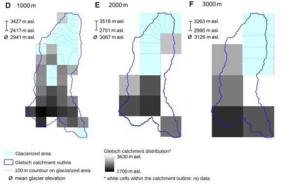
Experiment 2 fixed Grimsel forcing but varied DEM resolution from 25 m to 3000 m, based on SwissALTI3D topography, to evaluate effects on hypsometry and glacier detail.
Two calibration approaches were compared: single-data, fitting to geodetic volume change (from 2013–2021 DEMs, using melt factor and radiation coefficients); and multi-data, adding runoff measurements and tuning precipitation correction. Validation used RMSE for mass balance, NSE and KGE for runoff, and relative differences for seasonal partitions, against in-situ glacier measurements and gauged flows.
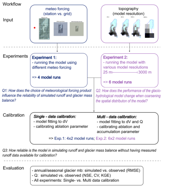
This framework, applied in a data-rich site, replicates constraints in less-monitored regions, providing benchmarks for model configuration.
Key Findings
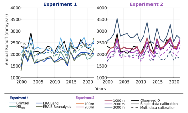
Precipitation differences across forcing products primarily influenced outcomes: gridded products like ERA5-Reanalysis underestimated winter accumulation, causing seasonal mass balance biases and up to 20% less simulated summer runoff relative to Grimsel-forced results. Annual mass balance aligned well with observations (RMSE approximately 0.3–0.5 m w.e.), but winter underestimation led to compensatory summer adjustments.
Spatial resolution was critical: resolutions coarser than 1000 m produced more positive mass balances, abrupt glacier retreat, and delayed runoff at 200–2000 m, with overestimation at 3000 m. Glacier area changes were gradual at finer scales but stepwise at coarser ones.
Single-data calibration performed well annually but showed seasonal biases from fixed precipitation. Multi-data calibration enhanced winter accuracy via 20–30% precipitation adjustments and improved runoff metrics (higher NSE and KGE), though limited by constant corrections unable to address time-varying biases. As noted in the study, “these findings highlight the trade-offs between computational efficiency and model reliability, emphasizing the need for high-resolution forcing data, particularly precipitation amount and seasonal variability, and careful calibration strategies.”
Implications for Hydrological Modeling
These insights suggest opportunities for refining models in data-scarce areas by prioritizing improved precipitation data and adaptive calibration, potentially enhancing projections of water availability.
We thank Alexandra von der Esch and her co-authors for their contributions to hydrological engineering. Readers with relevant expertise or data are encouraged to contact us for potential discussions or collaborations.
Reference: von der Esch, A., Huss, M., van Tiel, M., Berg, J., & Farinotti, D. (2025). Modelling runoff in a glacierized catchment: the role of forcing product and spatial model resolution. Hydrology and Earth System Sciences, 29(22), 6761–6780.https://doi.org/10.5194/hess-29-6761-2025.