This study utilizes LiDAR technology to improve understanding of habitat selection in large mammals, complementing traditional ecoforest maps. By integrating 3D vegetation structure data, researchers provide a nuanced view of wildlife habitats, potentially refining conservation strategies in eastern Canadian boreal forests.
Rethinking Habitat Selection in Large Mammals
The study of habitat selection in large mammals is crucial for wildlife conservation and management. Traditionally, researchers have relied on photo-interpreted forest maps to link the telemetry locations of animals to their environmental contexts. These maps, known as ecoforest maps in Quebec, provide valuable information on forest composition, age, and disturbance history. However, they fall short in detailing the structure of stands, which is a critical component of habitat quality. This limitation is significant, as the structure of vegetation, including understory conditions, plays a vital role in providing food resources and shelter for large mammals.
Ecoforest maps, while reliable, come with their own set of challenges. Their spatial resolution is relatively coarse, and they primarily capture information from the top of the canopy, offering little insight into the understory. This gap is particularly problematic because understory vegetation significantly influences the availability of resources and the protection from predators and harsh weather conditions. Moreover, these maps are updated infrequently, which can lead to outdated information in rapidly changing environments.
In contrast, LiDAR (Light Detection and Ranging) technology offers a promising alternative. LiDAR provides detailed 3D metrics of vegetation structure, capturing data from the canopy to the ground. This technology has been extensively used in forestry and is now being explored in wildlife studies. However, its application in understanding wildlife-habitat relationships, particularly for large mammals in eastern Canada, remains limited. This research aims to bridge this gap by integrating LiDAR data with traditional forest maps to improve our understanding of habitat selection patterns in species like caribou, moose, and eastern coyote.
Integrating LiDAR with Traditional Mapping
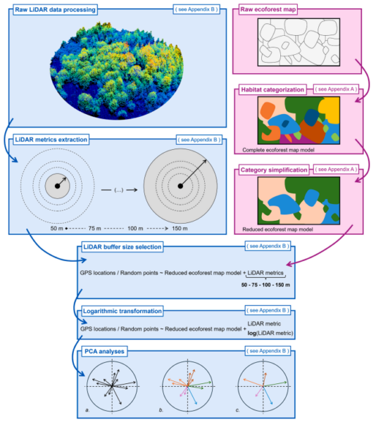
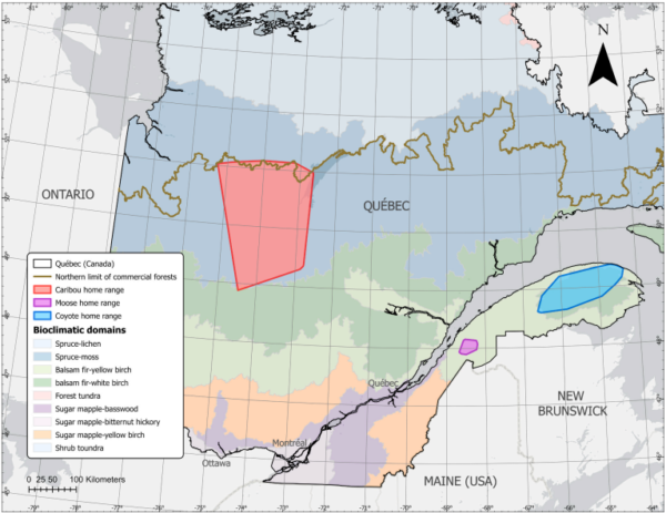
The research team embarked on an innovative approach by combining LiDAR-derived data with traditional ecoforest maps to study habitat selection patterns of large mammals in the eastern Canadian boreal forest. The study focused on three representative species: caribou, moose, and eastern coyote. By employing resource selection functions with mixed logistic regressions, the researchers were able to characterize habitat selection patterns using telemetry data and diverse sources of information on forest composition and structure.
To evaluate the effectiveness of this integrated approach, the researchers employed a k-fold cross-validation method. This statistical technique allowed them to assess the model’s performance and ensure its robustness across different periods and study areas. The integration of LiDAR data provided a more detailed view of vegetation structure, particularly the understory, which is often overlooked in traditional mapping methods.
LiDAR’s ability to penetrate all vegetation layers and provide a 3D “point cloud” dataset was pivotal in capturing the vertical and horizontal organization of vegetation. This detailed information was crucial in understanding how different species interact with their habitats. For instance, the study found that vegetation structure, as detailed by LiDAR, was a significant determinant for caribou and eastern coyotes during the snow-covered period. In contrast, forest composition, as described in the ecoforest maps, was more important for moose throughout the year.
Improved Habitat Characterization
The research findings indicate that integrating LiDAR data with traditional forest maps significantly enhances the ability to characterize habitat selection patterns across different species. The benefits of this integration varied depending on the species and the specific periods studied. For caribou and eastern coyotes, vegetation structure was the main determinant during the snow-covered period, highlighting the importance of understory conditions. On the other hand, moose habitat selection was more influenced by forest composition, regardless of the season.
These results underscore the complementary nature of LiDAR and traditional mapping methods. By providing a more comprehensive view of habitat structure, the integrated approach offers richer ecological insights. The study demonstrates that when used appropriately, combining these tools can lead to a more nuanced understanding of habitat selection patterns, which is crucial for effective wildlife management and conservation strategies.
Future Directions in Conservation
This research opens new avenues for wildlife conservation and habitat management. By integrating LiDAR with traditional forest maps, conservationists can gain a more detailed understanding of habitat structures and their influence on species behavior. This approach can guide practitioners in preserving specific habitat features, such as sparse understory for caribou, complex shrub structures for moose, and limiting dense cover for coyotes.
As LiDAR technology continues to evolve, its application in ecological studies is likely to expand, offering even more detailed insights into habitat dynamics. The study’s findings encourage further exploration of LiDAR’s potential in other regions and species, paving the way for more informed conservation efforts.
Reference: Blanchard, B., Schneider, R., Lesmerises, F., & St-Laurent, M.-H. (2026). LiDAR metrics enhance our understanding of habitat selection beyond ecoforest map habitat categories. Forest Ecology and Management, 609, 123665. DOI: https://doi.org/10.1016/j.foreco.2026.123665