The Perito Moreno Glacier, once noted for its stability, is now rapidly changing. Researchers used remote sensing and mass balance equations to measure its ablation rate, uncovering significant ice loss due to warming and droughts, signaling a vital shift in glacier dynamics.
Glacier Retreat: A Climate Change Indicator
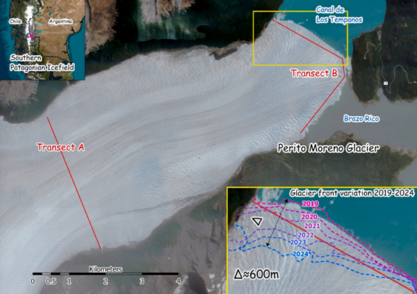
Glacier retreat is a significant indicator of climate change, contributing to sea-level rise and ecosystem alterations. The Perito Moreno Glacier, part of the Southern Patagonian Ice Field, was long considered stable due to its position on a subglacial ridge. Recent observations, however, indicate a shift, with the glacier experiencing rapid downwasting. Understanding Perito Moreno’s dynamics is crucial for insights into the broader impacts of climate change on global glaciers.
The Southern Patagonian Ice Field is the largest glacierized area outside Antarctica, significantly contributing to global sea-level rise. The region’s glaciers have experienced negative changes in area and mass, with substantial ice loss recorded in recent decades. Perito Moreno, specifically, shows signs of retreat beyond its stabilizing pinning point, driven by atmospheric warming and droughts. This transition underscores the need to accurately assess glacier mass balance components to forecast future changes and understand ice loss mechanisms.
Accurate assessment of glacier mass balance is essential for quantifying ice loss mechanisms. Traditionally, this involves estimating ice accumulation and ablation, influenced by temperature changes and precipitation patterns. However, these estimations are fraught with uncertainty, particularly in remote regions like the Patagonian Icefields. Remote sensing techniques have become invaluable in overcoming these challenges, providing detailed data on surface variations and ice volume changes. Yet, while methods for estimating calving are well established, surface ablation remains primarily measured through fieldwork, limiting large-scale analysis.
Innovative Research Methodology
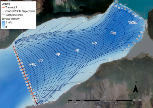
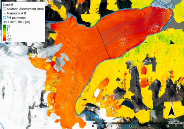
The research team used an innovative approach to assess the ablation rate of the Perito Moreno Glacier by integrating remote sensing data with the mass balance equation. This methodology combines satellite imagery and ground-penetrating radar (GPR) measurements to overcome the limitations of traditional fieldwork-based assessments. By processing images from Pléiades-SPOT satellites between 2015 and 2023, the researchers created digital elevation models to compute changes in ice thickness, revealing an average change of -2.7 meters per year in the glacier’s terminal area.
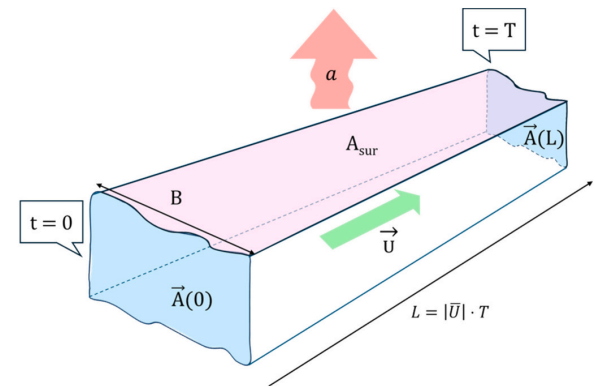
To calculate the ablation rate, the team solved the mass balance equation as a function of surface elevation change, velocity field, and ice thickness along two transects. Surface velocity data was derived from 88 Sentinel-2 images, processed using Imgraft software. This approach allowed the researchers to integrate the mass balance equation over the time required for the glacier to travel between the upstream and downstream transects, smoothing out local instabilities and providing robust results against the high uncertainty of pointwise velocities.
By focusing on the time integral of the mass balance equation, the researchers avoided the challenges associated with estimating ice flux at the transects, which often presents noticeable uncertainty. This methodological innovation provides a more reliable framework for assessing glacier ablation rates, particularly in regions where traditional data collection methods are challenging.
Significant Findings and Conclusions
The study found that the ablation rate at the Perito Moreno Glacier’s terminus was -16.4 meters water equivalent per year from 2015 to 2023. This rate is consistent with recent measurements from ablation stakes, validating the reliability of the proposed time integral framework. The results indicate significant ice loss, driven by atmospheric warming and droughts, causing the glacier front to retreat beyond its stabilizing pinning point.
The findings highlight the effectiveness of integrating remote sensing data with the mass balance equation to assess glacier dynamics. This approach provides a comprehensive understanding of the processes driving ice loss, offering valuable insights into the impacts of climate change on glacier stability. The study underscores the importance of continuous monitoring and assessment of glacier mass balance components to predict future changes accurately.
Future Directions and Global Implications
The research provides a crucial framework for assessing glacier ablation rates using remote sensing and mass balance equations, offering a more reliable and scalable method for monitoring glacier dynamics. This approach has significant implications for understanding the impacts of climate change on glaciers worldwide, particularly in remote and challenging regions like the Patagonian Icefields.
Future research could expand on this methodology by incorporating additional remote sensing data and exploring its application to other glaciers experiencing similar transitions. The study’s findings emphasize the need for continued innovation in glacier monitoring techniques to enhance our understanding of climate change’s impacts on global ice reserves.
We thank the authors for their valuable contribution to the field of glaciology. For those interested in further discussing this research or sharing insights, please reach out to the authors or engage with the broader scientific community.
Reference: Stucchi, L., Ferrarin, L., Riggio, C., Bocchiola, D., & Fugazza, D. (2026). Ablation rate of Perito Moreno Glacier assessed through the time integral of mass balance equation and remote sensing. Cold Regions Science and Technology, 247, 104917. DOI: https://doi.org/10.1016/j.coldregions.2026.104917