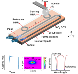
Elasto-Optic Transduction in Polymer-Cladded Silicon Microrings for 2D Force Mapping
Explore the potential of silicon photonic microring arrays coated with PDMS to detect localized forces through elasto-optic shifts, offering real-time mapping at micrometer resolution on flat surfaces, ideal for unbiased cellular studies and advancing mechanobiology, soft-matter metrology, and tactile interfaces in a scalable, biocompatible format. Addressing Microscale Force Measurement in Soft and Biological Matter Measuring […]
Elasto-Optic Transduction in Polymer-Cladded Silicon Microrings for 2D Force Mapping Read More »