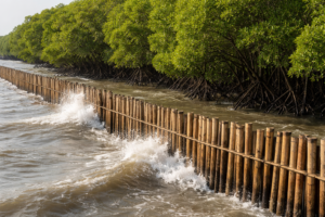
Bamboo Solutions for Mangrove Restoration
In Demak, Indonesia, a pilot deployment of bamboo and PVC permeable structures paired with systematic low-cost monitoring uncovers detailed seabed dynamics on a subsiding coast, highlighting both challenges and opportunities for nature-based mangrove restoration in complex coastal environments. Coastal Erosion and Subsidence: The Urgent Need for Effective Mangrove Restoration Mangroves provide essential coastal protection against […]
Bamboo Solutions for Mangrove Restoration Read More »