This study examines how forest vegetation density influences GNSS navigation accuracy for off-road vehicles. By assessing GNSS signal quality in different forest settings, the research aims to improve navigation solutions essential for forestry, autonomous vehicles, and off-road operations, addressing a critical need for reliable positioning.
Challenges in Forest Navigation
Global Navigation Satellite Systems (GNSS) like GPS, Galileo, GLONASS, and BeiDou are integral to modern navigation, providing precise positioning for various applications. However, their accuracy can be significantly compromised in dense forest environments. This is a pressing issue for sectors relying on reliable navigation, such as forestry, agriculture, military, and emergency services. In forested areas, tree trunks, branches, and leaves obstruct satellite signals, leading to positioning errors. Seasonal changes and rugged terrains further exacerbate these inaccuracies, making it challenging for off-road vehicles to navigate effectively.
The increasing use of GNSS for off-road vehicle movement in complex terrains, including forest units, highlights the need for improved navigation accuracy. Dense forest vegetation can distort the GNSS receiver’s actual position, affecting the mobility and operational efficiency of vehicles. The study’s focus on understanding these challenges is crucial for developing robust navigation solutions that ensure reliable positioning, even in challenging environments.
Innovative Research Approach
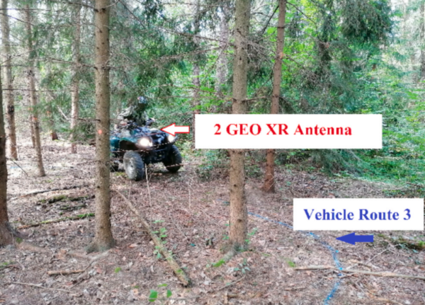
The research was conducted in a mixed temperate forest in the Czech Republic, aiming to verify the quality of GNSS signals for off-road vehicle navigation. The study utilized a comprehensive methodology to assess GNSS accuracy under varying forest densities. The researchers selected a representative forest stand accessible to mobile devices and employed different off-road vehicles, including light personal vehicles like the Land Rover LR 110, All-Terrain Toyota, heavy vehicles like the Tatra T815 8×8, and unmanned ground vehicles like the Taros 6×6 V2.
To ensure precise measurements, the team used tachymetry as a reference mapping tool to mark vehicle routes. GNSS signal quality was measured using the Trimble Geo 7X cm edition device with Tornado for 7 × antenna devices. The study involved surveying coordinates of reference ground control points and analyzing GNSS signal quality and quantity. The methodology included setting up GNSS receivers with specific configurations, such as measurement mode, logging interval, and antenna height, to optimize signal reception.
Three types of routes were designated for vehicle testing: a paved road with good GNSS signal reception, a forest path with partially limited reception, and a route through dense vegetation with limited signal reception. The routes were marked with reflective spray paint, and tachymetric precision measurements were conducted to ensure accuracy.
Key Findings and Insights
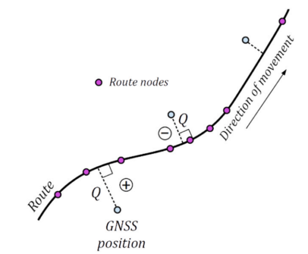
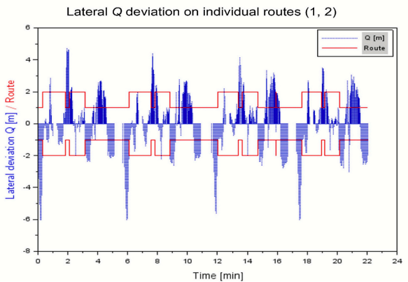
The study’s findings revealed significant variations in GNSS navigation accuracy depending on the density of forest vegetation. The results showed lateral deviations of vehicle positions recorded by the GNSS receiver from the reference tacheometrically measured paths. Statistical tests at the α = 0.05 significance level were used to evaluate the data, revealing mean deviations, quadratic means of deviations, and standard deviations.
The research demonstrated that GNSS accuracy is significantly impacted by forest density, with open spaces offering the best signal reception and dense forests presenting the most challenges. The study’s comprehensive analysis provides valuable insights into the factors affecting GNSS accuracy in forest environments, contributing to the development of more reliable navigation solutions for off-road vehicles.
Future Directions and Applications
This research underscores the importance of understanding GNSS signal behavior in forest environments, paving the way for improved navigation solutions in forestry and other off-road applications. By highlighting the impact of vegetation density on GNSS accuracy, the study offers a foundation for developing technologies that enhance positioning reliability in challenging terrains.
We thank the authors for their valuable contributions to this field. If you have insights or wish to collaborate, please reach out. Your input could drive further advancements in GNSS navigation technology.
Reference: Marian Rybansky, Vlastimil Kratochvil, Filip Dohnal, Ondrej Vystavel. “Effect of forest vegetation density on the accuracy of GNSS navigation.” Measurement 267 (2026): 120542. DOI: https://doi.org/10.1016/j.measurement.2026.120542