Researchers optimize Long Short-Term Memory (LSTM) models for street-scale flood prediction in Norfolk, Virginia. This study explores data grouping and model scalability, offering insights into enhancing prediction accuracy and efficiency. It addresses the need for rapid, reliable urban flood forecasts amid increasing climate challenges.
Urban Flooding: A Growing Challenge
Urban flooding is a pressing issue, especially in Norfolk, Virginia, where climate change and urbanization heighten flood risks. Accurate, real-time flood prediction is challenging due to the hydrological complexity of urban catchments. Traditional models, though precise, are computationally intensive and unsuitable for real-time needs, necessitating faster, reliable predictive models for timely flood warnings.
Long Short-Term Memory (LSTM) networks, a deep learning model, show promise for time series prediction in hydrology. However, the best training strategy for these models is debated. This study explores whether global models or localized, area-specific models offer superior predictive accuracy, focusing on enhancing LSTM model performance for street-scale flood prediction.
Innovative Research Approach
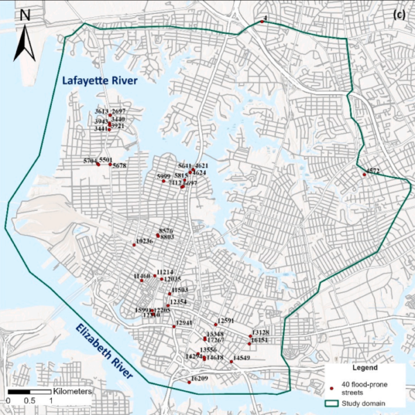
The study conducted experiments using data from 40 flood-prone streets in Norfolk, Virginia, to identify optimal LSTM model training strategies. It evaluated three approaches: comparing global, clustered, and street-specific data-grouping strategies for prediction accuracy; assessing the impact of varying water-depth information; and testing model scalability for newly added streets.
Simulating real-world conditions, researchers used physics-based model data for LSTM training, bypassing the need for actual street-level sensor data. This method assumed model data errors mirrored real-world observations, laying the groundwork for developing efficient flood prediction models.
Key Findings
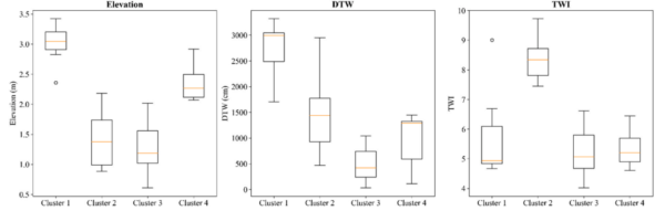
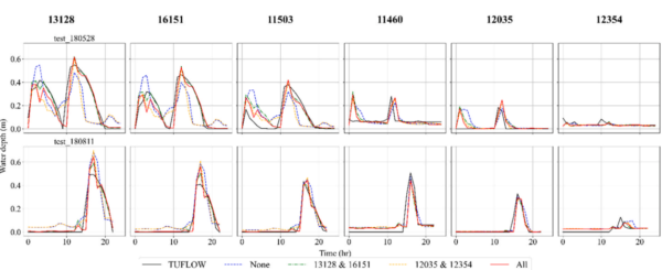
Grouping streets into hydrologically similar clusters significantly improved prediction accuracy over a global model. Street-specific models achieved the lowest errors, emphasizing the need for hyper-focused training to capture street-scale flooding dynamics. LSTM models trained on diverse flood depths performed well even for shallow water scenarios.
For newly added streets, clustered models outperformed the global model, indicating that datasets of hydrologically similar streets better capture flooding behavior. These findings highlight the potential of tailored LSTM models to enhance urban flood prediction accuracy and scalability.
Future Directions and Impact
This research offers insights into optimizing LSTM models for urban flood prediction, with implications for real-time flood warning systems. By demonstrating effective data-grouping strategies, it paves the way for accurate, efficient flood prediction models adaptable to various urban settings.
As street-level sensor networks grow, methodologies from this study could build robust flood prediction systems. The research underscores the potential for expanding observation networks and refining model training to boost urban flood resilience.
Interested in further exploration or contributing to this field? The authors welcome collaboration and discussion, setting a foundation for future innovations in urban flood prediction and management.
Reference: Jiwoo Jeong, Jonathan L. Goodall, Julianne D. Quinn. “Comparing strategies for training LSTM models for street-scale urban flood prediction in Norfolk, Virginia.” Journal of Hydrology: Regional Studies 65 (2026) 103405. DOI: https://doi.org/10.1016/j.ejrh.2026.103405