This study presents a rapid flood impact assessment framework using Sentinel-1 SAR data and Google Earth Engine, enhancing disaster response capabilities. Focusing on agricultural impacts in Northeast Thailand, it demonstrates high accuracy and temporal applicability across multiple flood events, supporting effective recovery strategies.
Flooding: A Persistent Threat to Agriculture
Flooding is among the most destructive natural disasters, severely impacting socio-economic structures globally, particularly in agricultural regions. Rapid and precise flood damage assessments are crucial for effective disaster management and recovery. Traditional methods, such as ground surveys and optical remote sensing, often fall short due to their labor-intensive nature and limitations under adverse weather conditions. Ground surveys are impractical in vast or hazardous areas, while optical sensors require clear skies, rendering them ineffective during storms when cloud cover is prevalent.
The agricultural sector, a cornerstone of the economy, is especially vulnerable to floods, which can lead to substantial crop losses, infrastructure damage, and disruptions in livelihoods. Existing flood assessment techniques often overlook critical factors such as terrain-induced backscatter distortions and fail to differentiate flood signals from soil moisture variations. These gaps highlight the need for a reliable and rapid assessment framework that can provide actionable insights for recovery efforts.
Recent advancements in remote sensing, particularly Synthetic Aperture Radar (SAR), offer promising solutions. SAR’s ability to penetrate clouds and provide reliable imaging during adverse weather makes it a valuable tool for flood impact assessment. However, many current methods lack the necessary agricultural focus, limiting their effectiveness in delivering precise and timely evaluations of flood impacts on crops. This research addresses these challenges by developing an innovative SAR-based framework tailored for rapid agricultural flood impact assessment.
Innovative Methods for Precise Assessments
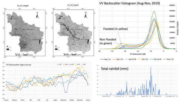
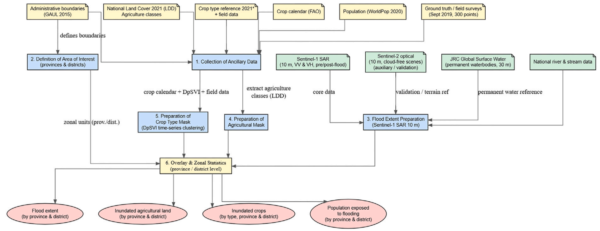
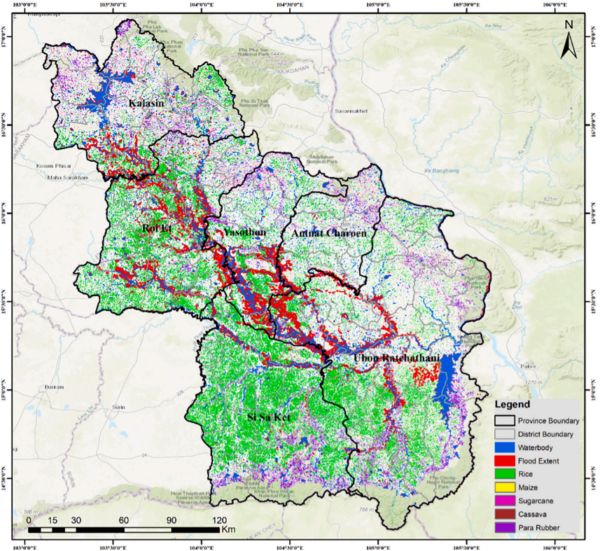
The study introduces a novel framework for rapid flood impact assessment on agriculture using Sentinel-1 Synthetic Aperture Radar (SAR) data at a 10-meter resolution, integrated with Google Earth Engine (GEE). This approach was applied to the September 2019 flood event in Northeast Thailand, triggered by Tropical Storm PODUL and Tropical Depression KAJIKI. The event affected several provinces, including Yasothon, Amnat Charoen, Ubon Ratchathani, Si Sa Ket, Roi Et, and Kalasin, causing substantial human and economic losses.
The methodology comprises three key components: flood mapping, crop classification, and robust validation. Flood mapping was achieved using an enhanced Kittler-Illingworth thresholding technique that incorporates terrain correction to mitigate slope-dependent backscatter variations. For crop classification, the researchers developed a novel Dual Polarization SAR Vegetation Index (DpSVI), which was validated against field data and optical imagery. This comprehensive analysis included flood extent determination, quantification of flooded agricultural areas, crop type distribution, and evaluation of farmers’ exposure to flooding throughout September 2019.
The framework’s innovation lies in its ability to provide rapid assessments within hours of new SAR data acquisition, leveraging automated processing in Google Earth Engine. This capability bypasses time-consuming manual analysis, enabling timely disaster response and supporting targeted recovery strategies. By integrating terrain-corrected flood mapping with crop-specific classification, the framework offers a robust solution for quantifying agricultural impacts across multiple flood events.
Key Findings and Their Significance
The study found that 3890.4 km2 (8.4% of the study area) was flooded, with Yasothon experiencing the highest agricultural impact, affecting 19.6% of its agricultural area. The framework demonstrated high accuracy, with an overall accuracy of 82.6% and a Kappa coefficient of 0.94. These findings underscore the framework’s effectiveness in providing reliable, cloud-independent flood and crop impact assessments.
The study also validated the framework’s temporal generalizability by testing it against flood events from 2018 and 2020, further confirming its robustness. By addressing critical gaps in existing methods, this research significantly advances flood assessment techniques, promoting effective disaster response and resilient agricultural monitoring systems at regional and national scales.
Future Directions and Broader Impact
This research offers a significant advancement in flood impact assessment, particularly for the agricultural sector. The ability to rapidly assess flood impacts with high accuracy and temporal generalizability can greatly enhance disaster response efforts and support targeted recovery strategies. The framework’s integration with Google Earth Engine allows for scalable and automated analysis, making it a valuable tool for regional and national disaster management agencies.
Future research could explore the application of this framework to other regions and crop types, further expanding its utility. The integration of additional data sources and machine learning techniques could also enhance the framework’s capabilities, providing even more precise and comprehensive assessments. The authors’ contribution to advancing flood assessment methodologies is invaluable, and their work invites further exploration and collaboration in this critical field.
Reference: Gautam Dadhich, Mukand S. Babel, Hiroyuki Miyazaki, Salvatore G.P. Virdis. “SAR based approach for rapid flood impact assessment on agriculture and human exposure.” Progress in Disaster Science, 2026. DOI: https://doi.org/10.1016/j.pdisas.2026.100558