LSTM Models for Flood Prediction
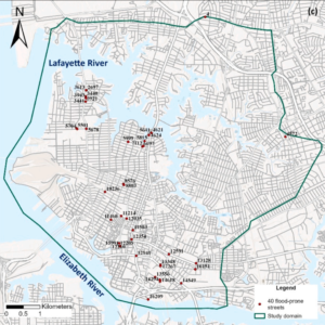
Researchers optimize LSTM models for street-scale flood prediction in Norfolk, Virginia, exploring data grouping and model scalability.
LSTM Models for Flood Prediction Read More »
Researchers optimize LSTM models for street-scale flood prediction in Norfolk, Virginia, exploring data grouping and model scalability.
LSTM Models for Flood Prediction Read More »
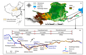
Researchers examine sedimentation dynamics in the Lower Yellow River, focusing on the Xiaolangdi Reservoir’s influence on sediment transport.
Dam Impact on River Sedimentation in Yellow River Read More »
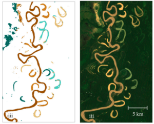
This study employs Google Earth Engine and Landsat 7 imagery alongside random forest classification to analyze multitemporal trends in oxbow lake area, water types, and hydrologic connectivity, providing insights into ecohydrological processes and fish habitat availability in data-scarce tropical river systems such as Bolivia’s Beni River. Challenges in Floodplain Dynamics Monitoring Meandering river floodplains, such
Remote Sensing for Oxbow Lake Monitoring in Turbid Floodplains Read More »
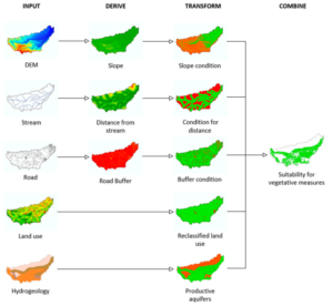
This research refines a GIS-based toolbox by integrating high-resolution land-cover data and new models for afforestation and riparian forest buffers, applied to six European river basins to map suitable locations for large-scale nature-based solutions that reduce hydrometeorological risks and highlight opportunities for combined implementations. Addressing the Escalating Hydrometeorological Risks with Nature-Based Solutions Climate change is
Annual Memory in the Terrestrial Water Cycle Read More »
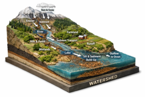
High-frequency turbidity sensors from 134 USGS stations, paired with RUSLE erosion estimates and explainable random forest models, map sediment yield and delivery ratios across the contiguous United States, revealing that human-modified landscapes dominate sediment transport efficiency while natural factors control total production, and highlighting priority sub-basins for targeted management in the Upper Mississippi and Chesapeake
Why Are Some Watersheds More Sediment-Productive Than Others? An Explainable AI Approach Read More »